IMAGES TAKEN NEAR TO
Hillside Close, BETCHWORTH, RH3 7ES
Introduction
This page details the photographs taken nearby to Hillside Close, RH3 7ES by members of the Geograph project.
The Geograph project started in 2005 with the aim of publishing, organising and preserving representative images for every square kilometre of Great Britain, Ireland and the Isle of Man.

There are currently over 7.5m images from over14,400 individuals and you can help contribute to the project by visiting https://www.geograph.org.uk
Image Map
Images are licensed for reuse under creativecommons.org/licenses/by-sa/2.0
Notes
- Clicking on the map will re-center to the selected point.
- The higher the marker number, the further away the image location is from the centre of the postcode.
Image Listing (32 Images Found)
Images are licensed for reuse under creativecommons.org/licenses/by-sa/2.0
Image
Details
Distance
1
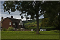
Access to Thames Water facility
Photo taken through a locked gate giving access to a Thames Water facility, presumably for sewage. In the background can be seen a small part of the remains of Betchworth Castle (see Image) - I believe that the end of The Borough, where this gate is situated, is the only place with public access from which the Castle can be seen, albeit to a very limited extent!
Image: © Ian Capper
Taken: 17 Apr 2010
0.05 miles
2
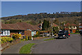
Hillside Gardens
A development of mainly bungalows to the north west of Brockham. In the background, on the top of the North Downs, is Brockham Warren, built by Mackley Browne in 1816, and subsequently the home of Sir Benjamin Vincent Sellon Brodie, Bt, the first president of the General Medical Council.
Image: © Ian Capper
Taken: 17 Apr 2010
0.06 miles
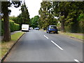
3
Brockham Lane
Ribbon development north of Brockham village, with Box Hill in the background.
Image: © Ian Capper
Taken: 7 May 2012
0.15 miles
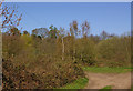
5
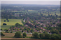
Brockham
Viewed from the North Downs Way. In the very far distance can be seen the South Downs.
Image: © Ian Capper
Taken: 7 Jun 2008
0.16 miles
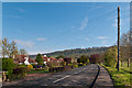
7
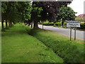
Brockham Lane
Entering Brockham from the north, with the "Big Field" to the feft of this avenue of trees.
www.brockham.org
Image: © Colin Smith
Taken: 29 Jun 2012
0.16 miles
8
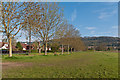
Brockham Lane
A line of trees dividing the National Trust owned Big Field from Brockham Lane, with the North Downs in the background.
Image: © Ian Capper
Taken: 7 May 2012
0.16 miles
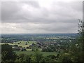
9

Brockham
The village of Brockham seen from Box Hill. On the far right is the spire of Christ Church, Brockham.
Image: © Ian Capper
Taken: 30 Jun 2012
0.17 miles
10
Brockham: The Avenue
Peace in rural Surrey
Image: © Dr Neil Clifton
Taken: 24 Jun 2015
0.17 miles