IMAGES TAKEN NEAR TO
Old Reigate Road, BETCHWORTH, RH3 7DQ
Introduction
This page details the photographs taken nearby to Old Reigate Road, RH3 7DQ by members of the Geograph project.
The Geograph project started in 2005 with the aim of publishing, organising and preserving representative images for every square kilometre of Great Britain, Ireland and the Isle of Man.

There are currently over 7.5m images from over14,400 individuals and you can help contribute to the project by visiting https://www.geograph.org.uk
Image Map
Images are licensed for reuse under creativecommons.org/licenses/by-sa/2.0
Notes
- Clicking on the map will re-center to the selected point.
- The higher the marker number, the further away the image location is from the centre of the postcode.
Image Listing (45 Images Found)
Images are licensed for reuse under creativecommons.org/licenses/by-sa/2.0
Image
Details
Distance
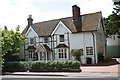
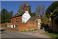
2
Morden Grange
A large Victorian/Edwardian house, now divided into flats.
Image: © Ian Capper
Taken: 24 Jul 2010
0.06 miles
3
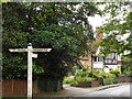
The Street, Betchworth
Fingerposts at the north end of the village's main street, at its junction with the Old Reigate Road.
Image: © Colin Smith
Taken: 29 Jun 2012
0.06 miles
4
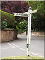
Betchworth Fingerposts
Old fingerposts at the junction of The Street and Old Road [to Reigate].
Image: © Colin Smith
Taken: 29 Jun 2012
0.06 miles
5
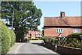
A bend in The Street
Betchworth's main road is called The Street. On the right is an old house with the traditional tiled upper storey.
Beyond the bend are a couple of new houses. One has gone for the tiled look, the other hasn't.
Image: © Des Blenkinsopp
Taken: 12 Aug 2024
0.08 miles
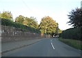
6
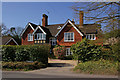
Ravenleigh
House in Station Road, dating from 1877.
Image: © Ian Capper
Taken: 17 Apr 2010
0.09 miles
7
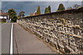
Wall in Station Road
Wall of Broome Park alongside Station Road. The wall is built of Reigate Stone and features small patches of "galleting", the insertion of pieces of stone in the mortar, possibly to protect it - one such section can be seen in the middle right hand edge of the photo. With thanks to fellow Geographer Stefan Czapski http://www.geograph.org.uk/profile/19114 for prompting me to search out this feature.
In the background is Bovey Cottage (see Image)
Image: © Ian Capper
Taken: 22 Apr 2012
0.09 miles
8
Yew Tree Cottage and gateway to Broome Park
Yew Tree Cottage dates from the late 17th century and is grade II listed - for listing particulars see www.historicengland.org.uk/listing/the-list/list-entry/1028777. The 18th century gateway to Broome Park is also grade II listed - for listing particulars see www.historicengland.org.uk/listing/the-list/list-entry/1378133.
Image: © Ian Capper
Taken: 17 Apr 2010
0.10 miles
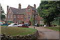
9
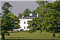
Broome Park
Once home to Queen Victoria's surgeon, Sir Benjamin Collins Brodie, Broome Park is now a nursing home.
Image: © Ian Capper
Taken: 27 May 2012
0.11 miles