IMAGES TAKEN NEAR TO
Howard Place, Reigate Hill, REIGATE, RH2 9NP
Introduction
This page details the photographs taken nearby to Howard Place, Reigate Hill, RH2 9NP by members of the Geograph project.
The Geograph project started in 2005 with the aim of publishing, organising and preserving representative images for every square kilometre of Great Britain, Ireland and the Isle of Man.

There are currently over 7.5m images from over14,400 individuals and you can help contribute to the project by visiting https://www.geograph.org.uk
Image Map
Images are licensed for reuse under creativecommons.org/licenses/by-sa/2.0
Notes
- Clicking on the map will re-center to the selected point.
- The higher the marker number, the further away the image location is from the centre of the postcode.
Image Listing (255 Images Found)
Images are licensed for reuse under creativecommons.org/licenses/by-sa/2.0
Image
Details
Distance
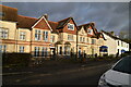
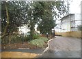
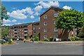
2
Flats on Orchards Place, Reigate
From Reigate Hill
Image: © David Howard
Taken: 6 Feb 2017
0.04 miles
4
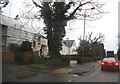
Reigate Hill, Reigate
The traffic is queuing at the level crossing by the station ahead.
Image: © David Howard
Taken: 17 Jan 2016
0.07 miles
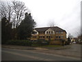
5
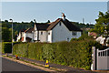
St Albans Road
Old maps show the road to have been laid out by 1914 and developed in the 1920s.
On the skyline can be seen the TV mast on Reigate Hill.
Image: © Ian Capper
Taken: 27 May 2012
0.09 miles
6
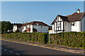
St Albans Road
Old maps show the road to have been laid out by 1914 and developed in the 1920s.
Image: © Ian Capper
Taken: 27 May 2012
0.09 miles
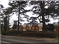
7
Somers Close
c.1980s/90s cul-de-sac off Somers Road by its junction with Reigate Hill, consisting of three 20 apartment blocks named after historic farms to the southwest of Reigate. Nearest is Littleton House, then Clayhall House, with Flanchford House beyond (not visible in this photo).
Image: © Ian Capper
Taken: 25 May 2020
0.10 miles
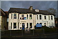
8
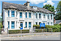
6 - 8 Somers Road
Pair of late Victorian semi-detached villas in Somers Road. No 8, on the left, has since the early 2000s housed the nursery section of Micklefield School, known as Belton House. see Image and Image for photos of the adjacent main building.
Image: © Ian Capper
Taken: 25 May 2020
0.10 miles