IMAGES TAKEN NEAR TO
Beech Road, REIGATE, RH2 9NA
Introduction
This page details the photographs taken nearby to Beech Road, RH2 9NA by members of the Geograph project.
The Geograph project started in 2005 with the aim of publishing, organising and preserving representative images for every square kilometre of Great Britain, Ireland and the Isle of Man.

There are currently over 7.5m images from over14,400 individuals and you can help contribute to the project by visiting https://www.geograph.org.uk
Image Map
Images are licensed for reuse under creativecommons.org/licenses/by-sa/2.0
Notes
- Clicking on the map will re-center to the selected point.
- The higher the marker number, the further away the image location is from the centre of the postcode.
Image Listing (80 Images Found)
Images are licensed for reuse under creativecommons.org/licenses/by-sa/2.0
Image
Details
Distance
1
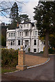
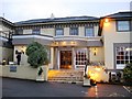
Cleveland, Beech Road
An impressive Victorian mansion in the Underhill area on Reigate Hill, now divided into flats. Locally listed.
Image: © Ian Capper
Taken: 21 Jan 2012
0.07 miles
2
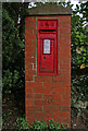
Edwardian postbox
With an OS benchmark in the pillar as an added bonus!
Image: © Ian Capper
Taken: 21 Apr 2008
0.08 miles
3
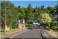
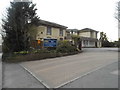
Redwood Mount
c1970s development off Beech Road, built on the site of a late 19th Century house named Craigendowie (later Southover).
Image: © Ian Capper
Taken: 6 Jun 2020
0.08 miles
4
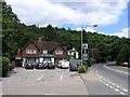
The Yew Tree public house, with Reigate Hill in the background
Reigate Hill can be seen leading off to the right and Reigate transmitter mast can be seen poking out of the trees above.
Image: © Hywel Williams
Taken: 19 Jul 2005
0.10 miles
7
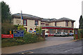
Reigate Manor Hotel
A Best Western Hotel on Reigate Hill. Originally a Georgian Manor House called The Brokes, and shown as such on maps of 1874 and 1897, much extended it subsequently became the Reigate Hill Hotel (see http://www.francisfrith.com/reigate/photos/hill-hotel-1935_R20001/ for 1935 photo), a name which still appears on a map of 1947. It was subsequently renamed the Reigate Manor Hotel.
Image: © Ian Capper
Taken: 12 Dec 2009
0.13 miles
8
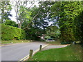
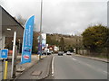
Approachingthe junction of Beech Road with Reigate Hill
The end of Beech Road has been narrowed to calm traffic. Reigate Hill is a busy - and not very wide - main A road leading to the M25 interchange at junction 8.
Image: © Ruth Sharville
Taken: 21 Sep 2018
0.13 miles
9
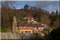
Pilgrims' Way bridleway
Linking Reigate Hill and Underhill Park Road, this is part of a linked series of paths that runs along the foot of the North Downs scarp. The near building The Coach House and beyond is Underbeeches. Underbeeches was built in the 1930s for James Alfred Goudge, who had had a long career in South America with the Buenos Aires and Pacific Railway Company, of which he had eventually become managing director. During the Second World War, it was used by General Montgomery as his headquarters.
Image: © Ian Capper
Taken: 21 Jan 2012
0.13 miles