IMAGES TAKEN NEAR TO
Bassett Drive, REIGATE, RH2 9JT
Introduction
This page details the photographs taken nearby to Bassett Drive, RH2 9JT by members of the Geograph project.
The Geograph project started in 2005 with the aim of publishing, organising and preserving representative images for every square kilometre of Great Britain, Ireland and the Isle of Man.

There are currently over 7.5m images from over14,400 individuals and you can help contribute to the project by visiting https://www.geograph.org.uk
Image Map
Images are licensed for reuse under creativecommons.org/licenses/by-sa/2.0
Notes
- Clicking on the map will re-center to the selected point.
- The higher the marker number, the further away the image location is from the centre of the postcode.
Image Listing (398 Images Found)
Images are licensed for reuse under creativecommons.org/licenses/by-sa/2.0
Image
Details
Distance
1
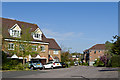
Bassett Drive
Development dating from 1999 on the old gasworks site.
Image: © Ian Capper
Taken: 6 May 2013
0.02 miles
2
2a Bassett Drive
Eco bungalow in Bassett Drive, built in the 2010s on part of the garden of 14 Yorke Road.
Image: © Ian Capper
Taken: 7 Apr 2020
0.04 miles
3
Summerly Avenue
1970s housing in a small estate off Yorke Road.
Image: © Ian Capper
Taken: 27 Apr 2013
0.06 miles
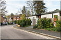
5
1 - 7 East Road
Two pairs of semi-detached mid Victorian cottages in East Road. Old maps give the road other names: Gashouse Road on the 1871-2 1:2,500 map and Gasworks Road on the 1896 edition, both names referring to the gasworks at the end of the road. The current name first appears on the 1935 edition.
Image: © Ian Capper
Taken: 8 May 2020
0.07 miles
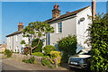
7

1 - 7 East Road
Two pairs of semi-detached mid Victorian cottages in East Road. Old maps give the road other names: Gashouse Road on the 1871 1:2,500 map and Gasworks Road on the 1896 edition, both names referring to the gasworks at the end of the road. The current name first appears on the 1935 edition.
Image: © Ian Capper
Taken: 25 May 2020
0.07 miles
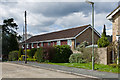
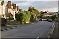
9
East Road
An 1870s map show this road as Gasworks Road, reflecting the siting of the town gasworks at its end. This name is also shown in the 1896 and 1914 maps, but by 1935 it had been given its current name, East Road. Although the gasholders went in the 1960/70s, the site remained the local depot for British Gas until the 1990s, when it was redeveloped for housing (as seen in the background). However East Road itself has retained its Victorian character.
Image: © Ian Capper
Taken: 18 Aug 2012
0.08 miles
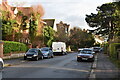
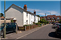
10
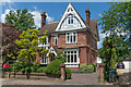
26 Somers Road
c.1880s house in Somers Road, built from brick with tile hanging.
Image: © Ian Capper
Taken: 25 May 2020
0.08 miles