IMAGES TAKEN NEAR TO
Colley Way, REIGATE, RH2 9JH
Introduction
This page details the photographs taken nearby to Colley Way, RH2 9JH by members of the Geograph project.
The Geograph project started in 2005 with the aim of publishing, organising and preserving representative images for every square kilometre of Great Britain, Ireland and the Isle of Man.

There are currently over 7.5m images from over14,400 individuals and you can help contribute to the project by visiting https://www.geograph.org.uk
Image Map
Images are licensed for reuse under creativecommons.org/licenses/by-sa/2.0
Notes
- Clicking on the map will re-center to the selected point.
- The higher the marker number, the further away the image location is from the centre of the postcode.
Image Listing (151 Images Found)
Images are licensed for reuse under creativecommons.org/licenses/by-sa/2.0
Image
Details
Distance
1
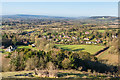
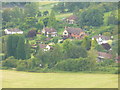
Colley Way
Looking down on the houses of Colley Way from the main path up Colley Hill, with Leith Hill in the left background and the line of the North Downs on the right.
Image: © Ian Capper
Taken: 4 Mar 2016
0.01 miles
2
Colley Way and Clears Cottages
Looking down on Colley Way from Colley Hill, with Clears Cottages beyond.
Image: © Ian Capper
Taken: 30 Jun 2013
0.01 miles
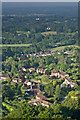
3
Colley Lane from the Greensand Way
Select housing area below the North Downs scarp slope at Reigate.
Image: © Colin Smith
Taken: 10 Jul 2011
0.02 miles
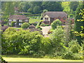
4
Towards Colley Lane
Looking towards houses in Colley Way, with one in Colley Lane behind, framed in a tree alongside the Greensand Way as it passes Broadleas.
Image: © Ian Capper
Taken: 18 Apr 2014
0.02 miles
5
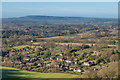
Colley Lane from Colley Hill
Bird's eye view of an upmarket residential area on the north-western edge of Reigate - ideally placed for walking the Buckland Hills of the North Downs.
Image: © Colin Smith
Taken: 10 Jul 2011
0.02 miles
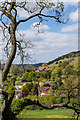
6
Colley Way
Looking down on the houses of Colley Way from Colley Hill, with Leith Hill in the background.
Image: © Ian Capper
Taken: 4 Mar 2016
0.04 miles
7
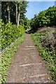
Sheepwalk
This track was presumably once a route used for the Hearthstone Quarry that was sited where it meets the North Downs below Colley Hill, with the wooden slats being to protect it from rutting in wet weather. The hedge on the left is at the back of a garden in Colley Way.
Image: © Ian Capper
Taken: 18 May 2018
0.06 miles
8
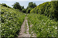
Sheepwalk
This track was presumably once a route used for the Hearthstone Quarry that was sited where it meets the North Downs below Colley Hill, with the wooden slats being to protect it from rutting in wet weather. The hedge on the right is at the back of a garden in Colley Way.
Image: © Ian Capper
Taken: 18 May 2018
0.08 miles
9
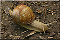
Roman Snail (Helix pomatia)
Britain's largest snail (this specimen was around 9 cm long), it is believed to have been introduced by the Romans, hence the name. It is found on southern chalk (as here, on a site near the base of the North Downs). Due to concerns about overharvesting for the restaurant trade, it has since 2008 been protected under the Wildlife and Countryside Act 1981, making collection illegal.
Image: © Ian Capper
Taken: 7 Jun 2009
0.10 miles
10
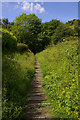
Sheepwalk
This track was presumably once a route used for the Hearthstone Quarry that was sited where it meets the North Downs below Colley Hill, with the wooden slats being to protect it from rutting in wet weather.
Image: © Ian Capper
Taken: 7 Jun 2009
0.10 miles