IMAGES TAKEN NEAR TO
Coppice Lane, REIGATE, RH2 9JE
Introduction
This page details the photographs taken nearby to Coppice Lane, RH2 9JE by members of the Geograph project.
The Geograph project started in 2005 with the aim of publishing, organising and preserving representative images for every square kilometre of Great Britain, Ireland and the Isle of Man.

There are currently over 7.5m images from over14,400 individuals and you can help contribute to the project by visiting https://www.geograph.org.uk
Image Map
Images are licensed for reuse under creativecommons.org/licenses/by-sa/2.0
Notes
- Clicking on the map will re-center to the selected point.
- The higher the marker number, the further away the image location is from the centre of the postcode.
Image Listing (141 Images Found)
Images are licensed for reuse under creativecommons.org/licenses/by-sa/2.0
Image
Details
Distance
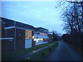
1
Reigate: Coppice Lane
This shows the southern end of Coppice Lane (south of the railway bridge), which is just a footpath.
Image: © Dr Neil Clifton
Taken: 26 Aug 2013
0.02 miles
2

Bridge over the railway
This is Coppice Lane which here crosses the railway line between Reigate, which is a short distance to the left, and Betchworth. See http://www.geograph.org.uk/photo/4045689
Image: © Marathon
Taken: 25 Jun 2014
0.02 miles
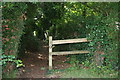
3
Reigate: view from Coppice Lane railway bridge
Looking west, towards Dorking
Image: © Dr Neil Clifton
Taken: 26 Aug 2013
0.03 miles
4
Coppice Lane railway bridge
Unadopted road over the Reigate to Guildford railway, with Reigate Squash Club behind.
Image: © Ian Capper
Taken: 10 Oct 2010
0.03 miles
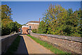
5
West of Reigate Station
First Great Western 3 car unit 166 213 on the 08.03 Gatwick Airport to Reading service, having just left Reigate Station, the platforms of which are visible beyond the footbridge. The car in the background is on the A217, where it crosses the railway on a level crossing just to the west of the station. The footbridge is for pedestrians avoiding the level crossing - the station itself has a subway.
Image: © Ian Capper
Taken: 20 Sep 2008
0.05 miles
6
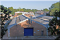
Albert Road North Industrial Estate
A small industrial estate in an otherwise residential area.
Image: © Ian Capper
Taken: 10 Oct 2010
0.05 miles
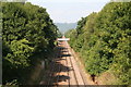
7

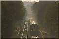
View along the line from Coppice Lane bridge
The line was opened by the Reading, Guildford & Reigate Railway on 4th July 1849. This became part of the South Eastern Railway in 1852.
Trains here are currently operated by First Great Western which is a long way out of their usual territory. The next station in this direction is Betchworth. Reigate station is behind where I am standing, and this is the limit of the third rail. Southern Trains from Redhill terminate there whereas all the First Great Western trains west of Reigate, as here, are diesel.
Image: © Marathon
Taken: 25 Jun 2014
0.05 miles
8
Former nursery buildings, Old Colley Farm
Somewhere in this undergrowth are the remains of some former nursery buildings (see Image for view from a different angle). Planning permission is currently being sought for their demolition, with replacement by a new house.
Image: © Ian Capper
Taken: 7 Nov 2009
0.05 miles
9
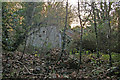
Former nursery buildings, Old Colley Farm
Planning permission is currently being sought for the demolition of these buildings, with replacement by a new house.
Image: © Ian Capper
Taken: 7 Nov 2009
0.05 miles