IMAGES TAKEN NEAR TO
RH2 9EP
Introduction
This page details the photographs taken nearby to RH2 9EP by members of the Geograph project.
The Geograph project started in 2005 with the aim of publishing, organising and preserving representative images for every square kilometre of Great Britain, Ireland and the Isle of Man.

There are currently over 7.5m images from over14,400 individuals and you can help contribute to the project by visiting https://www.geograph.org.uk
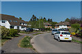
Image Map
Images are licensed for reuse under creativecommons.org/licenses/by-sa/2.0
Notes
- Clicking on the map will re-center to the selected point.
- The higher the marker number, the further away the image location is from the centre of the postcode.
Image Listing (174 Images Found)
Images are licensed for reuse under creativecommons.org/licenses/by-sa/2.0
Image
Details
Distance
1
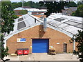
Industrial Estate, Reigate
Long sawtooth-roofed blocks in western Reigate, adjacent to the railway line like many industrial areas.
Image: © Colin Smith
Taken: 10 Jul 2011
0.04 miles
2
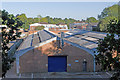
Albert Road North Industrial Estate
A small industrial estate in an otherwise residential area.
Image: © Ian Capper
Taken: 10 Oct 2010
0.04 miles
3
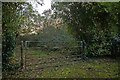
Former nursery buildings, Old Colley Farm
Somewhere in this undergrowth are the remains of some former nursery buildings (see Image for view from a different angle). Planning permission is currently being sought for their demolition, with replacement by a new house.
Image: © Ian Capper
Taken: 7 Nov 2009
0.05 miles
4
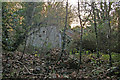
Former nursery buildings, Old Colley Farm
Planning permission is currently being sought for the demolition of these buildings, with replacement by a new house.
Image: © Ian Capper
Taken: 7 Nov 2009
0.05 miles
5
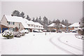
Evesham Close
1930s mixture of houses and (at the far end) maisonettes. Shown here after what is reputed to be the heaviest snow in the area for 18 years.
Image: © Ian Capper
Taken: 2 Feb 2009
0.05 miles
6
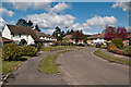
Evesham Close
Early 1960s mixture of houses and (at the far end) maisonettes.
Image: © Ian Capper
Taken: 15 Apr 2012
0.05 miles
7
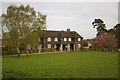
Pavilion Cottages
Grade II listed former cricket pavilion with two cottages, designed in 1937 by Sir Edwin and Robert Lutyens for Sir William Mallinson of Pine End (a large house nearby, now a nursing home). Converted into two dwellings in around 1950. For listing particulars, see www.historicengland.org.uk/listing/the-list/list-entry/1029048.
Image: © Ian Capper
Taken: 26 Apr 2008
0.06 miles
8
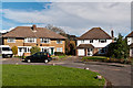
Evesham Close
c1950s mixture of maisonettes and houses. In the background is Reigate Hill TV transmitter.
Image: © Ian Capper
Taken: 2 Nov 2012
0.06 miles
9
Evesham Close
c1950s mixture of maisonettes and houses (although some of the houses have been modernised over the years).
Image: © Ian Capper
Taken: 24 Apr 2020
0.07 miles
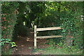
10
Reigate: Coppice Lane
This shows the southern end of Coppice Lane (south of the railway bridge), which is just a footpath.
Image: © Dr Neil Clifton
Taken: 26 Aug 2013
0.07 miles