IMAGES TAKEN NEAR TO
Evesham Close, REIGATE, RH2 9DN
Introduction
This page details the photographs taken nearby to Evesham Close, RH2 9DN by members of the Geograph project.
The Geograph project started in 2005 with the aim of publishing, organising and preserving representative images for every square kilometre of Great Britain, Ireland and the Isle of Man.

There are currently over 7.5m images from over14,400 individuals and you can help contribute to the project by visiting https://www.geograph.org.uk
Image Map
Images are licensed for reuse under creativecommons.org/licenses/by-sa/2.0
Notes
- Clicking on the map will re-center to the selected point.
- The higher the marker number, the further away the image location is from the centre of the postcode.
Image Listing (272 Images Found)
Images are licensed for reuse under creativecommons.org/licenses/by-sa/2.0
Image
Details
Distance
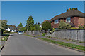
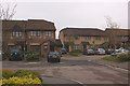
1
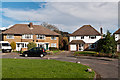
Evesham Close
c1950s mixture of maisonettes and houses. In the background is Reigate Hill TV transmitter.
Image: © Ian Capper
Taken: 2 Nov 2012
0.02 miles
2
Evesham Close
c1950s mixture of maisonettes and houses (although some of the houses have been modernised over the years).
Image: © Ian Capper
Taken: 24 Apr 2020
0.03 miles
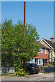
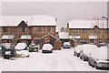
3
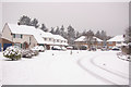
Evesham Close
1930s mixture of houses and (at the far end) maisonettes. Shown here after what is reputed to be the heaviest snow in the area for 18 years.
Image: © Ian Capper
Taken: 2 Feb 2009
0.03 miles
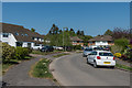
4
Evesham Close
Early 1960s mixture of houses and (at the far end) maisonettes.
Image: © Ian Capper
Taken: 15 Apr 2012
0.03 miles
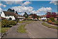
5
Evesham Close
c1950s mixture of maisonettes and houses (although some of the houses have been modernised over the years).
Image: © Ian Capper
Taken: 24 Apr 2020
0.03 miles
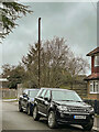
6
Sewer vent column
A sewer vent column (or "stinkpipe") in Evesham Road North.
Image: © Ian Capper
Taken: 24 Apr 2020
0.05 miles
7
Sewer vent column
A sewer vent column (or "stinkpipe") in Evesham Road North. This photo was taken a couple of days after Storm Eunice had passed through, a major storm which saw the usual combination of fallen trees and branches, flattened fences and tiles off roofs. This column was a further victim, with the cap at its top distorted, as seen here.
Image: © Ian Capper
Taken: 20 Feb 2022
0.05 miles
8
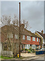
Sewer vent column
A sewer vent column (or "stinkpipe") in Evesham Road North. This photo was taken a couple of days after Storm Eunice had passed through, a major storm which saw the usual combination of fallen trees and branches, flattened fences and tiles off roofs. This column was a further victim, with the cap at its top distorted, as seen here.
Image: © Ian Capper
Taken: 20 Feb 2022
0.05 miles
9
Churchfield Road
At first appearance, an ordinary modern housing development, but in fact it is one with great historic relevance to the Geograph project. Shown on an 1895 street map of Reigate on this site is "Photographic Printing Works", being the place from where Francis Frith & Co. operated. The Francis Frith collection is the largest collection of historic photos of day to day life in the UK, essentially the 19th/20th century Geograph - to quote http://en.wikipedia.org/wiki/Francis_Frith Francis Frith "embarked upon a colossal project — to photograph every town and village in the United Kingdom; in particular, notable historical or interesting sights." See http://www.francisfrith.com/ for the results.
It is unfortunate that Francis Frith's name is not commemorated in this development - in fact it is not clear why the name Churchfield Road was chosen, as there is no obvious ecclesiastical connection. However, the Frith name is commemorated elsewhere in Reigate - see Image and Image He is also named on a tombstone in Reigate cemetery (see Image).
The site subsequently (in the 1920s?) was redeveloped as an essence factory operated by White, Tompkins and Courage Ltd, "distillers of essential oils, fruit and flavouring essences; manufacturer of fine chemicals and flower oils". This was demolished in the early 1990s, with Churchfield Road being built in its place.
Image: © Ian Capper
Taken: 20 Apr 2008
0.06 miles
10
Churchfield Road
Shown here after what is reputed to be the heaviest snow in the area for 18 years. See Image for further info and what it looks like without snow cover.
Image: © Ian Capper
Taken: 2 Feb 2009
0.06 miles