IMAGES TAKEN NEAR TO
Bellingham Drive, REIGATE, RH2 9BB
Introduction
This page details the photographs taken nearby to Bellingham Drive, RH2 9BB by members of the Geograph project.
The Geograph project started in 2005 with the aim of publishing, organising and preserving representative images for every square kilometre of Great Britain, Ireland and the Isle of Man.

There are currently over 7.5m images from over14,400 individuals and you can help contribute to the project by visiting https://www.geograph.org.uk
Image Map
Images are licensed for reuse under creativecommons.org/licenses/by-sa/2.0
Notes
- Clicking on the map will re-center to the selected point.
- The higher the marker number, the further away the image location is from the centre of the postcode.
Image Listing (221 Images Found)
Images are licensed for reuse under creativecommons.org/licenses/by-sa/2.0
Image
Details
Distance
1
Bellingham Drive
A gated development of flats built in 2005 on West Street.
Image: © Ian Capper
Taken: 3 Sep 2011
0.01 miles
2
Charlwood Place
A gated development of flats built in 2005 on West Street.
Image: © Ian Capper
Taken: 3 Sep 2011
0.03 miles
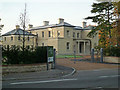
3
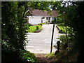
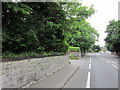
West Street
Footpath and modern bungalows on the main road west from Reigate.
Image: © Colin Smith
Taken: 10 Jul 2011
0.06 miles
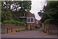
4
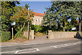
Rutland Home
A care home in West Street. The footpath on the left forms part of the Greensand Way, and runs up to Coppice Lane.
Image: © Ian Capper
Taken: 10 Oct 2010
0.06 miles
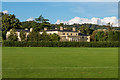
5
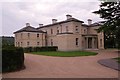
Wallfield Park
Wallfield (the large house in the centre of the photo) is a grade II listed Italianate villa built in the 1840s. The architect was T R Knowles. For listing particulars see https://www.historicengland.org.uk/listing/the-list/list-entry/1377966.
For many years it was used by Reigate School of Art and Design, but fell into disuse in the 1980s. It has now been redeveloped into luxury apartments, with four new matching villas built in the grounds (of which the block to the left of the main building is an example).
Image: © Ian Capper
Taken: 25 Oct 2008
0.07 miles
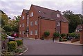
6
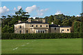
Wallfield Park
The rear of Wallfield, a grade II listed Italianate villa built in the 1840s. The architect was T R Knowles. For listing particulars see https://www.historicengland.org.uk/listing/the-list/list-entry/1377966.
For many years it was used by Reigate School of Art and Design, but fell into disuse in the 1980s. It has now been redeveloped into luxury apartments, with four new matching villas built in the grounds.
Image: © Ian Capper
Taken: 30 Sep 2016
0.08 miles
7
Wallfield Park
The rear of Wallfield, a grade II listed Italianate villa built in the 1840s. The architect was T R Knowles. For listing particulars see https://www.historicengland.org.uk/listing/the-list/list-entry/1377966.
For many years it was used by Reigate School of Art and Design, but fell into disuse in the 1980s. It has now been redeveloped into luxury apartments, with four new matching villas built in the grounds.
In the background is Reigate Hill, topped by its TV transmitter.
Image: © Ian Capper
Taken: 30 Sep 2016
0.08 miles
8
Wallfield Park
Wallfield is a grade II listed Italianate villa built in the 1840s. The architect was T R Knowles. For listing particulars see https://www.historicengland.org.uk/listing/the-list/list-entry/1377966.
For many years it was used by Reigate School of Art and Design, but fell into disuse in the 1980s. It has now been redeveloped into luxury apartments, with four new matching villas built in the grounds.
Image: © Ian Capper
Taken: 3 Sep 2011
0.08 miles
9
Wallfield Park
Wallfield is a grade II listed Italianate villa built in the 1840s. The architect was T R Knowles. For listing particulars see https://www.historicengland.org.uk/listing/the-list/list-entry/1377966.
For many years it was used by Reigate School of Art and Design, but fell into disuse in the 1980s. It has now been redeveloped into luxury apartments, with four new matching villas built in the grounds.
Image: © Ian Capper
Taken: 3 Sep 2011
0.08 miles