IMAGES TAKEN NEAR TO
Duxhurst Lane, REIGATE, RH2 8QQ
Introduction
This page details the photographs taken nearby to Duxhurst Lane, RH2 8QQ by members of the Geograph project.
The Geograph project started in 2005 with the aim of publishing, organising and preserving representative images for every square kilometre of Great Britain, Ireland and the Isle of Man.

There are currently over 7.5m images from over14,400 individuals and you can help contribute to the project by visiting https://www.geograph.org.uk
Image Map
Images are licensed for reuse under creativecommons.org/licenses/by-sa/2.0
Notes
- Clicking on the map will re-center to the selected point.
- The higher the marker number, the further away the image location is from the centre of the postcode.
Image Listing (11 Images Found)
Images are licensed for reuse under creativecommons.org/licenses/by-sa/2.0
Image
Details
Distance
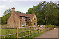
1
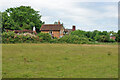
Duxhurst
Some of a range of buildings at this settlement reached via private roads.
Image: © Robin Webster
Taken: 18 Jul 2010
0.01 miles
2
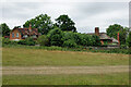
Duxhurst
Some of a range of buildings at this settlement reached via private roads.
Image: © Robin Webster
Taken: 18 Jul 2010
0.02 miles
3
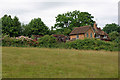
Duxhurst
Some of a range of buildings at this settlement reached via private roads.
Image: © Robin Webster
Taken: 18 Jul 2010
0.03 miles
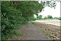
4
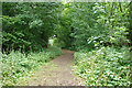
Bridleway 413 Salfords & Sidlow
Westwards towards Crutchfield Lane.
Image: © Robin Webster
Taken: 18 Jul 2010
0.07 miles
5
Old route of bridleway towards Reigate Road
As long ago as around 1900 the path was diverted to run along the field edge to the left. Presumably the ditch or stream to the right caused problems in winter. In July this old route is more pleasant and interesting than the new.
Image: © Robin Webster
Taken: 18 Jul 2010
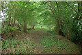
0.12 miles
6
Old route of bridleway towards Crutchfield Lane
As long ago as around 1900 the path was diverted to run along the field edge to the right. Presumably the ditch or stream to the left caused problems in winter. In July this old route is more pleasant and interesting than the new.
Image: © Robin Webster
Taken: 18 Jul 2010
0.12 miles
7
Bridleway 413 Salfords & Sidlow
From Reigate Road towards Crutchfield Lane.
Image: © Robin Webster
Taken: 18 Jul 2010
0.15 miles
8
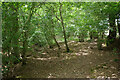
Old route of bridleway towards Crutchfield Lane
As long ago as around 1900 the path was diverted to run along the field edge to the right. Presumably the ditch or stream to the left caused problems in winter. In July this old route is more pleasant and interesting than the new.
Image: © Robin Webster
Taken: 18 Jul 2010
0.15 miles
9
New house, Crutchfield Lane
New house replacing a previous house on the site.
Image: © Ian Capper
Taken: 5 Jul 2009
0.17 miles
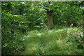
10
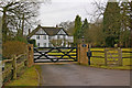
Duxhurst Place
Duxhurst was the site of The Duxhurst Hospital for Lady Inebriates, founded by Lady Henry Somerset of Reigate Priory in 1894. Lady Henry Somerset was a stalwart of the temperance movement and built a model village here for the care and recuperation of women affected by alcoholism, many from the East End of London. For more information see the excellent article on her and her work at http://www.redhill-reigate-history.co.uk/ladysomerset.htm.
The current Duxhurst Place is on the site of a building called The Nest, used to house children of women being cared for in the village. Whether Duxhurst Place is the original building or a replacement building on the site is not clear.
Image: © Ian Capper
Taken: 13 Mar 2010
0.17 miles