IMAGES TAKEN NEAR TO
Dean Oak Lane, REIGATE, RH2 8PX
Introduction
This page details the photographs taken nearby to Dean Oak Lane, RH2 8PX by members of the Geograph project.
The Geograph project started in 2005 with the aim of publishing, organising and preserving representative images for every square kilometre of Great Britain, Ireland and the Isle of Man.

There are currently over 7.5m images from over14,400 individuals and you can help contribute to the project by visiting https://www.geograph.org.uk
Image Map
Images are licensed for reuse under creativecommons.org/licenses/by-sa/2.0
Notes
- Clicking on the map will re-center to the selected point.
- The higher the marker number, the further away the image location is from the centre of the postcode.
Image Listing (6 Images Found)
Images are licensed for reuse under creativecommons.org/licenses/by-sa/2.0
Image
Details
Distance
1
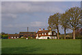
Dean Oak Farm
At the junction of Dean Oak Lane and Ironsbottom.
Image: © Ian Capper
Taken: 19 Apr 2009
0.04 miles
3
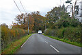
Ironsbottom heading north
Towards Sidlow.
Image: © Robin Webster
Taken: 19 Nov 2022
0.12 miles
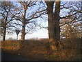
5
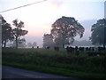
Sunrise at Irons Bottom
Just before dawn - during a partial solar eclipse
Image: © James Insell
Taken: 31 May 2003
0.15 miles
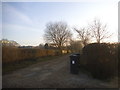
6
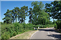
Deanoak Lane
The drive to Stumblehole goes left at the concrete cylinders.
Image: © Robin Webster
Taken: 10 Jul 2010
0.23 miles