IMAGES TAKEN NEAR TO
Shellwood Road, REIGATE, RH2 8NX
Introduction
This page details the photographs taken nearby to Shellwood Road, RH2 8NX by members of the Geograph project.
The Geograph project started in 2005 with the aim of publishing, organising and preserving representative images for every square kilometre of Great Britain, Ireland and the Isle of Man.

There are currently over 7.5m images from over14,400 individuals and you can help contribute to the project by visiting https://www.geograph.org.uk
Image Map
Images are licensed for reuse under creativecommons.org/licenses/by-sa/2.0
Notes
- Clicking on the map will re-center to the selected point.
- The higher the marker number, the further away the image location is from the centre of the postcode.
Image Listing (8 Images Found)
Images are licensed for reuse under creativecommons.org/licenses/by-sa/2.0
Image
Details
Distance
1
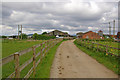
Shellwood Manor Farm
Mention of the Manor of Shellwood goes back to at least the 12th century.
Image: © Ian Capper
Taken: 30 May 2010
0.05 miles
2
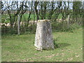
Ordnance Survey Trig Pillar S3279
This Pillar can be found in a paddock near Shellwood Manor.
Image: © Peter Wood
Taken: 3 Apr 2012
0.15 miles
3

Agricultural heap of what?
Looking like cat litter or unweathered blue clay, this large heap is probably neither.
Image: © Robin Webster
Taken: 11 Jul 2010
0.17 miles
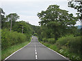
5
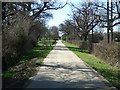
Shellwood Road
Towards Shellwood Cross.
Image: © Robin Webster
Taken: 24 Apr 2021
0.21 miles
7
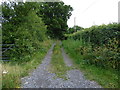
Byway to Little Shellwood
Open to all traffic.
Image: © Dr Neil Clifton
Taken: 24 Jun 2015
0.23 miles
8
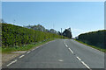
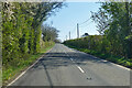
Shellwood Road
Southwards towards Shellwood Cross.
Image: © Robin Webster
Taken: 24 Apr 2021
0.24 miles