IMAGES TAKEN NEAR TO
North Road, REIGATE, RH2 8NB
Introduction
This page details the photographs taken nearby to North Road, RH2 8NB by members of the Geograph project.
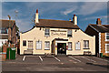
The Geograph project started in 2005 with the aim of publishing, organising and preserving representative images for every square kilometre of Great Britain, Ireland and the Isle of Man.

There are currently over 7.5m images from over14,400 individuals and you can help contribute to the project by visiting https://www.geograph.org.uk
Image Map
Images are licensed for reuse under creativecommons.org/licenses/by-sa/2.0
Notes
- Clicking on the map will re-center to the selected point.
- The higher the marker number, the further away the image location is from the centre of the postcode.
Image Listing (76 Images Found)
Images are licensed for reuse under creativecommons.org/licenses/by-sa/2.0
Image
Details
Distance
1
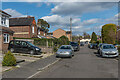
North Road
Road in South Park, with initial development in the late 19th Century but some later. In the distance is the former Barley Mow pub in Eastnor Road. on North Road, until the c1960s the only building on the north side of that road.
Image: © Ian Capper
Taken: 3 Apr 2020
0.03 miles
2
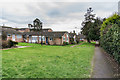
Eastnor Close
c1960s bungalows off Park Lane East. Maps suggest that they replace a previous development, with the 1961 1:1,250 map showing a different layout of housing, where nothing was shown on the 1935 1:2.500 map.
Image: © Ian Capper
Taken: 10 Jan 2020
0.04 miles
3
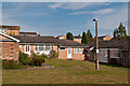
Eastnor Close
Low rise houses off Park Lane East, operated by Raven Housing Trust.
Image: © Ian Capper
Taken: 15 Sep 2012
0.04 miles
4
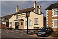
The Barley Mow
Early 19th century pub in Eastnor Road. Locally listed.
Image: © Ian Capper
Taken: 15 Sep 2012
0.04 miles
5
The Barley Mow
Early 19th century pub in Eastnor Road. Locally listed.
Image: © Ian Capper
Taken: 15 Sep 2012
0.04 miles
6
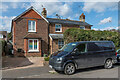
8 & 10 North Road
Late 19th Century on North Road, until the c1960s the only building on the north side of that road.
Image: © Ian Capper
Taken: 3 Apr 2020
0.04 miles
7
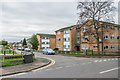
Roman House
Apartment block on Park Lane East, built in the c1960s. Beyond, down Eastnor Road, is another similar building, Saxon House.
Image: © Ian Capper
Taken: 10 Jan 2020
0.04 miles
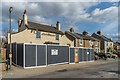
8
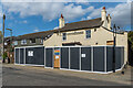
Former Barley Mow
Former pub in Eastnor Road which closed in 2018. See Image for when open as a pub. In this photo work is under way to convert it to a physio clinic and hydrotherapy centre.
Image: © Ian Capper
Taken: 3 Apr 2020
0.04 miles
9
Former Barley Mow
Former pub in Eastnor Road which closed in 2018. See Image for when open as a pub. In this photo work is under way to convert it to a physio clinic and hydrotherapy centre.
Image: © Ian Capper
Taken: 3 Apr 2020
0.04 miles
10

Eastnor Road
19th Century housing in Eastnor Road. Behind the hoardings is the former Barley Mow pub (see Image) which closed in 2018. In this photo work is under way to convert it to a physio clinic and hydrotherapy centre.
Image: © Ian Capper
Taken: 3 Apr 2020
0.04 miles