IMAGES TAKEN NEAR TO
Park Lane, REIGATE, RH2 8JT
Introduction
This page details the photographs taken nearby to Park Lane, RH2 8JT by members of the Geograph project.
The Geograph project started in 2005 with the aim of publishing, organising and preserving representative images for every square kilometre of Great Britain, Ireland and the Isle of Man.

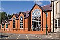
There are currently over 7.5m images from over14,400 individuals and you can help contribute to the project by visiting https://www.geograph.org.uk
Image Map
Images are licensed for reuse under creativecommons.org/licenses/by-sa/2.0
Notes
- Clicking on the map will re-center to the selected point.
- The higher the marker number, the further away the image location is from the centre of the postcode.
Image Listing (936 Images Found)
Images are licensed for reuse under creativecommons.org/licenses/by-sa/2.0
Image
Details
Distance
1
Stable Mews
1990s conversion of former stables.
Image: © Ian Capper
Taken: 20 Jun 2009
0.01 miles
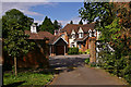
2
Pilgrim Mews
A 2009 development off Park Lane. On the left is the back of buildings in the High Street.
Image: © Ian Capper
Taken: 26 Jul 2009
0.02 miles
3
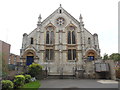
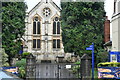
Reigate Methodist Church
Located at 53 High Street RH2 9AE, this church dates from 1884 and is one of five Methodist churches in the Redhill & East Grinstead Circuit, the others being in Crawley, East Grinstead, Horley and Redhill. Services are held here each Sunday at 10.30am, with activities taking place during the week.
Image: © David Hillas
Taken: 8 Sep 2018
0.02 miles
4
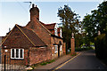
Former Lodge to Reigate Priory
16th century lodge to Reigate Priory, alongside the 18th century gateposts. These once included wrought iron gates, but they were apparently damaged by a Canadian armoured vehicle during the Second World War and removed for safe keeping. The gates were rediscovered in the 1990s when ground clearance was taking place nearby in preparation for the building of Safeways supermarket (now Morrisons) - see Image
The gateposts are grade II listed - see www.historicengland.org.uk/listing/the-list/list-entry/1241295.
Image: © Ian Capper
Taken: 13 May 2012
0.03 miles
5
Reigate Community Centre
Formally opened on 9 July 2011, this new centre attached to Reigate Methodist Church replaced the former Rank Memorial Hall (see Image).
Image: © Ian Capper
Taken: 24 Jul 2011
0.03 miles
7
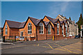
Reigate Community Centre
Formally opened on 9 July 2011, this new centre attached to Reigate Methodist Church (seen in the background) replaced the former Rank Memorial Hall (see Image).
Image: © Ian Capper
Taken: 24 Mar 2012
0.03 miles
8
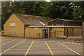
Rank Hall, Reigate Methodist Church
Named after J Arthur Rank (of flour and film fame), who was a prominent member of this church (see Image).
Image: © Ian Capper
Taken: 27 Aug 2008
0.03 miles
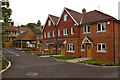
9
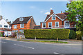
Park Lane
Edwardian villas in Park Lane.
Image: © Ian Capper
Taken: 24 Apr 2020
0.04 miles
10
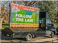
COVID-19 advertising van, Priory Park - 1
One of a number of advertising message vans provided by Surrey Council touring popular spots in Surrey. Their purpose was to remind people about rules during "lockdown 3" which started on 5 January 2021 in response to a surge in COVID-19 cases. This one is parked up in Priory Park. Its display was cycling through 8 different messages - for the full set see www.geograph.org.uk/search.php?i=127176349.
Image: © Ian Capper
Taken: 9 Jan 2021
0.04 miles