IMAGES TAKEN NEAR TO
Hitchings Way, REIGATE, RH2 8EN
Introduction
This page details the photographs taken nearby to Hitchings Way, RH2 8EN by members of the Geograph project.
The Geograph project started in 2005 with the aim of publishing, organising and preserving representative images for every square kilometre of Great Britain, Ireland and the Isle of Man.

There are currently over 7.5m images from over14,400 individuals and you can help contribute to the project by visiting https://www.geograph.org.uk
Image Map
Images are licensed for reuse under creativecommons.org/licenses/by-sa/2.0
Notes
- Clicking on the map will re-center to the selected point.
- The higher the marker number, the further away the image location is from the centre of the postcode.
Image Listing (35 Images Found)
Images are licensed for reuse under creativecommons.org/licenses/by-sa/2.0
Image
Details
Distance
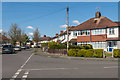
1
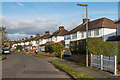
Hitchings Way
Housing in an area that started to be developed in the 1930s.
Image: © Ian Capper
Taken: 17 Feb 2017
0.03 miles
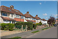
2
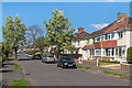
Hartswood Avenue
Housing in an area that started to be developed in the 1930s.
Image: © Ian Capper
Taken: 18 Apr 2015
0.04 miles
3
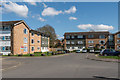
Castle Close
Cul-de-sac off Castle Drive, with housing operated by Raven Housing Trust. On the left is Arundel House and in the background Pevensey House.
Image: © Ian Capper
Taken: 18 Apr 2015
0.05 miles
4
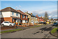
Hitchings Way
Housing in an area that started to be developed in the 1930s.
Image: © Ian Capper
Taken: 17 Feb 2017
0.07 miles
5
Hartswood Avenue
Housing in an area that started to be developed in the 1930s. This is Hartswood Avenue, with Baron's Way on the right.
Image: © Ian Capper
Taken: 18 Apr 2015
0.10 miles
6
Baron's Way
Housing in an area that started to be developed in the 1930s.
Image: © Ian Capper
Taken: 18 Apr 2015
0.11 miles
7
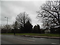
Dovers Green Road
The A217 stretch between Reigate and Horley
Image: © David Howard
Taken: 31 Jan 2016
0.12 miles
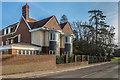
8
Dovers
Late 17th century house, locally listed. According to the council list it was later remodelled by Newton - presumably the architect Ernest Newton. It now serves as an old people's home.
Image: © Ian Capper
Taken: 21 Aug 2012
0.12 miles
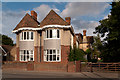
9
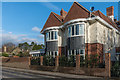
Dovers
Late 17th century house, locally listed. According to the council list it was later remodelled by Newton - presumably the architect Ernest Newton. For many years it served as an old people's home, but has recently been converted to housing, with the house itself split into two. Compare Image
Image: © Ian Capper
Taken: 17 Feb 2017
0.12 miles
10
Dovers
Late 17th century house, locally listed. According to the council list it was later remodelled by Newton - presumably the architect Ernest Newton. For many years it served as an old people's home, but has recently been converted to housing, with the house itself split into two. Compare Image
Image: © Ian Capper
Taken: 17 Feb 2017
0.12 miles