IMAGES TAKEN NEAR TO
Lonesome Lane, REIGATE, RH2 7RE
Introduction
This page details the photographs taken nearby to Lonesome Lane, RH2 7RE by members of the Geograph project.
The Geograph project started in 2005 with the aim of publishing, organising and preserving representative images for every square kilometre of Great Britain, Ireland and the Isle of Man.

There are currently over 7.5m images from over14,400 individuals and you can help contribute to the project by visiting https://www.geograph.org.uk
Image Map
Images are licensed for reuse under creativecommons.org/licenses/by-sa/2.0
Notes
- Clicking on the map will re-center to the selected point.
- The higher the marker number, the further away the image location is from the centre of the postcode.
Image Listing (27 Images Found)
Images are licensed for reuse under creativecommons.org/licenses/by-sa/2.0
Image
Details
Distance

3
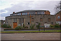
St Peter's Church, Doversgreen
Built in 1955 to serve a post war housing development in the south of Reigate.
Update in 2010: The building ceased to be used as a church in 2008 and was sold to a private owner in 2010.
Image: © Ian Capper
Taken: 5 Jan 2008
0.06 miles
4
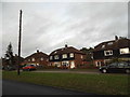
Arden Close
Part of the late 1950s/early 1960s Woodhatch estate.
Image: © Ian Capper
Taken: 21 Aug 2012
0.14 miles
5
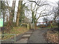
The entrance to Lonesome Lane Recreation Ground
Image: © David Howard
Taken: 31 Jan 2016
0.14 miles
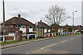
6

Barrier on Lonesome Lane, Doversgreen
This is the beginning of the suburban area of Reigate.
Image: © David Howard
Taken: 31 Jan 2016
0.16 miles
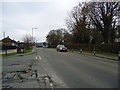
7
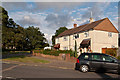
Dovers Green Road
1930s housing. For close up of the milestone next to the postbox on the left of the photo, see Image
Image: © Ian Capper
Taken: 28 Apr 2013
0.17 miles
9
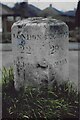
Old Milestone, A217, Dovers Green Road, North of Sandcross Lane Junction
The milestone is located by the pillar box on the verge by the service area, on the West side of the road. Parish of Reigate (Reigate And Banstead district). Carved stone post, Lesser Surrey limestone pillar design, erected by the Reigate turnpike trust in the 19th century.
Inscription reads:
LONDON / 22 / REIGATE / 1 :: BRIGHTON / 29(⅜) / CRAWLEY / 7 ⅝
Grade II Listed, List entry number: 1294792 https://historicengland.org.uk/listing/the-list/list-entry/1294792
The photograph was probably taken before 2001.
Milestone Society National ID: SY_LQR22
Image: © Derek Renn
Taken: Unknown
0.17 miles
10
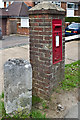
Milestone, Dovers Green Road
Close up of the milestone in Image, alongside a post box set in a brick pillar.
The milestone is one of a series dating from 1817 along what is now the A217, but prior to the building of the A23 through Redhill in 1818, was once the main London to Brighton road. It reads "LONDON 22 REIGATE 1 3/8" on this face and "BRIGHTON 29 5/8 CRAWLEY 7 5/8" on the reverse. This example is grade II listed - see www.historicengland.org.uk/listing/the-list/list-entry/1294792.
Image: © Ian Capper
Taken: 28 Apr 2013
0.17 miles