IMAGES TAKEN NEAR TO
Lonesome Lane, REIGATE, RH2 7QU
Introduction
This page details the photographs taken nearby to Lonesome Lane, RH2 7QU by members of the Geograph project.
The Geograph project started in 2005 with the aim of publishing, organising and preserving representative images for every square kilometre of Great Britain, Ireland and the Isle of Man.

There are currently over 7.5m images from over14,400 individuals and you can help contribute to the project by visiting https://www.geograph.org.uk
Image Map
Images are licensed for reuse under creativecommons.org/licenses/by-sa/2.0
Notes
- Clicking on the map will re-center to the selected point.
- The higher the marker number, the further away the image location is from the centre of the postcode.
Image Listing (8 Images Found)
Images are licensed for reuse under creativecommons.org/licenses/by-sa/2.0
Image
Details
Distance
1
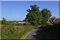
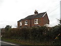
Lonesome Lane
Brook Cottage on the right, White Owl Farm in the distance on the left.
Image: © Ian Capper
Taken: 26 Apr 2009
0.12 miles
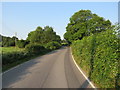
3
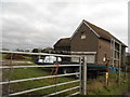
Bridge over Salfords Stream
The road bridge over Salfords Stream. Some buildings belonging to Lonesome Farm can be seen in the background and a small weir was observed through the trees to the right of the picture.
Image: © Hywel Williams
Taken: 18 Oct 2005
0.19 miles
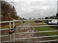
4
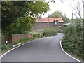
Lonesome Lane, Surrey
Southbound as the lane approaches the bridge over the Salfords Stream.
Image: © Richard Rogerson
Taken: 24 Jun 2020
0.19 miles
6
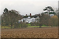
Kinnersley Manor
Originally dating from 1579, when it was called Kimlersley Manor, this Grade II building was altered and added to in the 18th and 19th centuries. For listing particulars, see www.historicengland.org.uk/listing/the-list/list-entry/1257998.
Image: © Ian Capper
Taken: 13 Mar 2010
0.23 miles