IMAGES TAKEN NEAR TO
Tilers Way, REIGATE, RH2 7PJ
Introduction
This page details the photographs taken nearby to Tilers Way, RH2 7PJ by members of the Geograph project.
The Geograph project started in 2005 with the aim of publishing, organising and preserving representative images for every square kilometre of Great Britain, Ireland and the Isle of Man.

There are currently over 7.5m images from over14,400 individuals and you can help contribute to the project by visiting https://www.geograph.org.uk
Image Map
Images are licensed for reuse under creativecommons.org/licenses/by-sa/2.0
Notes
- Clicking on the map will re-center to the selected point.
- The higher the marker number, the further away the image location is from the centre of the postcode.
Image Listing (14 Images Found)
Images are licensed for reuse under creativecommons.org/licenses/by-sa/2.0
Image
Details
Distance
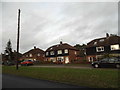
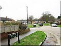
2
Felland Way
1950s housing in Felland Way.
Image: © Ian Capper
Taken: 4 Aug 2018
0.14 miles

4
Felland Way
1950s housing in Felland Way.
Image: © Ian Capper
Taken: 4 Aug 2018
0.15 miles
5
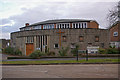
St Peter's Church, Doversgreen
Built in 1955 to serve a post war housing development in the south of Reigate.
Update in 2010: The building ceased to be used as a church in 2008 and was sold to a private owner in 2010.
Image: © Ian Capper
Taken: 5 Jan 2008
0.15 miles
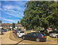
7
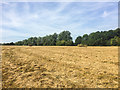
Behind Felland Way
Area of grassland behind Felland Way.
Image: © Ian Capper
Taken: 4 Aug 2018
0.18 miles
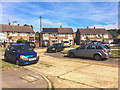
9
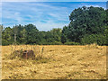
Behind Felland Way
Area of grassland behind Felland Way.
Image: © Ian Capper
Taken: 4 Aug 2018
0.19 miles
10
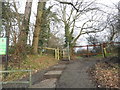
The entrance to Lonesome Lane Recreation Ground
Image: © David Howard
Taken: 31 Jan 2016
0.20 miles