IMAGES TAKEN NEAR TO
West Road, REIGATE, RH2 7JU
Introduction
This page details the photographs taken nearby to West Road, RH2 7JU by members of the Geograph project.
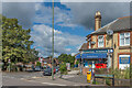
The Geograph project started in 2005 with the aim of publishing, organising and preserving representative images for every square kilometre of Great Britain, Ireland and the Isle of Man.

There are currently over 7.5m images from over14,400 individuals and you can help contribute to the project by visiting https://www.geograph.org.uk
Image Map
Images are licensed for reuse under creativecommons.org/licenses/by-sa/2.0
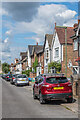
Notes
- Clicking on the map will re-center to the selected point.
- The higher the marker number, the further away the image location is from the centre of the postcode.
Image Listing (409 Images Found)
Images are licensed for reuse under creativecommons.org/licenses/by-sa/2.0
Image
Details
Distance
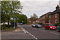
1
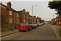
West Road
At its junction with Chart Lane, with Lesbourne Road beyond. The housing on the left dates from the late 19th century.
Image: © Ian Capper
Taken: 26 Jul 2009
0.01 miles
2
West Road
Looking along West Road from its junction with Chart Lane. The building in the centre, 24 West Road, houses a firm of Chartered Surveyors.
Image: © Ian Capper
Taken: 19 Apr 2014
0.02 miles
3
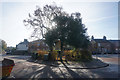
Island garden on Chart Lane
At the junction with West Road.
Image: © Bill Boaden
Taken: 11 Nov 2016
0.02 miles
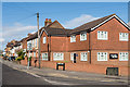
4
Reigate: No 1, Blackborough Road
This newsagent's shop is at the extreme western end of Blackborough Road, at the Chart Lane crossing. West of here, the name of the road changes to West Road for a short distance.
Image: © Dr Neil Clifton
Taken: 18 Apr 2011
0.02 miles
5
West Road
Seen here at its junction with Chart Lane, at which point it becomes Blackborough Road. In the background is Reigate TA Centre (see Image).
Image: © Ian Capper
Taken: 13 May 2012
0.02 miles
6
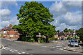
Chart Lane
Chart Lane where it crosses West Road/Blackborough Road.
Image: © Ian Capper
Taken: 15 Jun 2013
0.03 miles
7
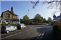
Chart Lane
Crossing the end of Blackborough Road. In the middle is an army reserve centre.
Image: © Bill Boaden
Taken: 11 Nov 2016
0.03 miles
8
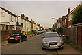
Lesbourne Road
Housing mainly dating from the late 19th/early 20th century.
Image: © Ian Capper
Taken: 26 Jul 2009
0.03 miles
9
Lesbourne Road
Mainly Victorian housing in Lesbourne Road - the ones further from the camera are marked on the 1871 1:2,500 map.
Image: © Ian Capper
Taken: 31 Aug 2020
0.03 miles
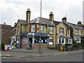
10
Sri Sai News
Corner shop on the corner of Chart Lane and Blackborough Road.
Image: © Ian Capper
Taken: 31 Aug 2020
0.03 miles