IMAGES TAKEN NEAR TO
Effingham Road, REIGATE, RH2 7JN
Introduction
This page details the photographs taken nearby to Effingham Road, RH2 7JN by members of the Geograph project.
The Geograph project started in 2005 with the aim of publishing, organising and preserving representative images for every square kilometre of Great Britain, Ireland and the Isle of Man.

There are currently over 7.5m images from over14,400 individuals and you can help contribute to the project by visiting https://www.geograph.org.uk
Image Map
Images are licensed for reuse under creativecommons.org/licenses/by-sa/2.0
Notes
- Clicking on the map will re-center to the selected point.
- The higher the marker number, the further away the image location is from the centre of the postcode.
Image Listing (313 Images Found)
Images are licensed for reuse under creativecommons.org/licenses/by-sa/2.0
Image
Details
Distance
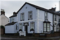
1
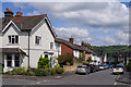
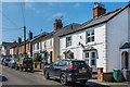
Effingham Road
1860s housing (the near house has a date plaque of 1867). In the background is Reigate Hill, topped by Reigate Hill TV transmitter.
Image: © Ian Capper
Taken: 25 May 2013
0.01 miles
2
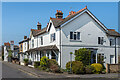
Parkgate Road
Parkgate Road at its junction with Effingham Road. The nearer building has date plaques of 1867, with the next along being dated 1866. When first developed, the road was called Reigate Park Road, although mapping shows it to have received its present name by 1895.
Image: © Ian Capper
Taken: 19 Apr 2021
0.01 miles
3
Parkgate Road
Parkgate Road at its junction with Effingham Road. The nearer building has date plaques of 1867, with the next along being dated 1866. When first developed, the road was called Reigate Park Road, although mapping shows it to have received its present name by 1895.
Image: © Ian Capper
Taken: 25 May 2013
0.01 miles
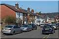
4
Reigate: Effingham Road
Looking south from its junction with Lesbourne Road
Image: © Dr Neil Clifton
Taken: 18 Apr 2011
0.01 miles
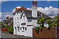
5
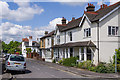
Effingham Cottage
House on the corner of Parkgate Road and Effingham Road, with a date plaque of 1864.
Image: © Ian Capper
Taken: 2 Nov 2013
0.02 miles
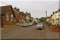
6
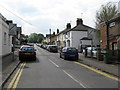
Effingham Road
Victorian housing in Effingham Road.
Image: © Ian Capper
Taken: 19 Apr 2021
0.02 miles
7
Effingham Road
One of a pair of roads commemorating Howard of Effingham, Admiral of the Fleet that defeated the Spanish Armada in 1588, who lived in Reigate Priory and is buried in St Mary's Church. See Image
Image: © Ian Capper
Taken: 26 Jul 2009
0.02 miles
8
Sydneyville
House in Parkgate Road at its junction with Howard Road. This was the home of cricketer William ("Billy") Caffyn, Surrey cricketer in the 1850s who in the 1860s had a spell in Australia, mainly in Sydney, where he played a significant role in the development of cricket there. He lived in this house from his return in 1871 through to his death in 1891 and name it in commemoration of his time there.
Above the front door is a blue plaque that reads "William Caffyn 1828 - 1891, cricketing legend England and Surrey CCC, lived here".
Image: © Ian Capper
Taken: 25 May 2013
0.03 miles
9
Effingham Road
One of a pair of roads commemorating Howard of Effingham, Admiral of the Fleet that defeated the Spanish Armada in 1588, who lived in Reigate Priory and is buried in St Mary's Church. The buildings on this stretch are first shown on the 1871 1:2,500 map.
Image: © Ian Capper
Taken: 25 Apr 2020
0.03 miles
10
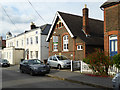
The Old School House, Effingham Road, Reigate
Now offices, but still with the bell in place, with above it the date 1880.
Image: © Robin Webster
Taken: 21 Jul 2016
0.03 miles