IMAGES TAKEN NEAR TO
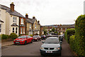
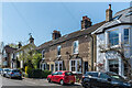
St. Marys Road, REIGATE, RH2 7JH
Introduction
This page details the photographs taken nearby to St. Marys Road, RH2 7JH by members of the Geograph project.
The Geograph project started in 2005 with the aim of publishing, organising and preserving representative images for every square kilometre of Great Britain, Ireland and the Isle of Man.

There are currently over 7.5m images from over14,400 individuals and you can help contribute to the project by visiting https://www.geograph.org.uk
Image Map
Images are licensed for reuse under creativecommons.org/licenses/by-sa/2.0
Notes
- Clicking on the map will re-center to the selected point.
- The higher the marker number, the further away the image location is from the centre of the postcode.
Image Listing (270 Images Found)
Images are licensed for reuse under creativecommons.org/licenses/by-sa/2.0
Image
Details
Distance
1
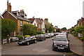
St Mary's Road
Part of the late 19th/early 20th century development of this part of Reigate. Seen here at its junction with Oakhill Road (on the right of the photo) looking towards Chart Lane in the background.
Image: © Ian Capper
Taken: 26 Jul 2009
0.01 miles
2
St Mary's Road
Part of the late 19th/early 20th century development of this part of Reigate. Seen here with Oakhill Road turning off to the right.
Image: © Ian Capper
Taken: 26 Jul 2009
0.03 miles
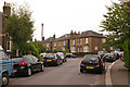
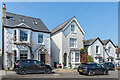
3
Glovers Road
Part of the late 19th/early 20th century development of this part of Reigate. Looking towards Chart Lane in the background.
Image: © Ian Capper
Taken: 26 Jul 2009
0.03 miles
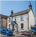
4
St Mary's Road
Part of the late 19th/early 20th century development of this part of Reigate. Seen here at its junction with Oakhill Road (on the left of the photo). "Covent Garden House" was presumably once a greengrocer's shop.
Image: © Ian Capper
Taken: 26 Jul 2009
0.04 miles
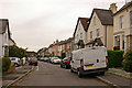
5
Oakhill Road
Part of the late 19th/early 20th century development of this part of Reigate. Seen here looking towards its junction with St Mary's Road.
Image: © Ian Capper
Taken: 26 Jul 2009
0.04 miles
6
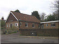
Woodlands Chapel
A small independent chapel in St Mary's Road
Image: © Ian Capper
Taken: 23 Feb 2008
0.06 miles
7
35 South Road
Late Victorian house in South Road.
Image: © Ian Capper
Taken: 19 Apr 2021
0.06 miles
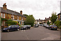
8
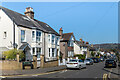
South Road
Mainly 19th Century housing in South Road.
Image: © Ian Capper
Taken: 19 Apr 2021
0.06 miles
9
South Road
Victorian housing in South Road. The plaques on the building in the middle of the read "Osborne Cottage" and "AD 1870".
Image: © Ian Capper
Taken: 19 Apr 2021
0.06 miles
10
South Road
19th Century housing in South Road.
Image: © Ian Capper
Taken: 19 Apr 2021
0.07 miles