IMAGES TAKEN NEAR TO
Furzefield Road, REIGATE, RH2 7HG
Introduction
This page details the photographs taken nearby to Furzefield Road, RH2 7HG by members of the Geograph project.
The Geograph project started in 2005 with the aim of publishing, organising and preserving representative images for every square kilometre of Great Britain, Ireland and the Isle of Man.

There are currently over 7.5m images from over14,400 individuals and you can help contribute to the project by visiting https://www.geograph.org.uk
Image Map
Images are licensed for reuse under creativecommons.org/licenses/by-sa/2.0
Notes
- Clicking on the map will re-center to the selected point.
- The higher the marker number, the further away the image location is from the centre of the postcode.
Image Listing (113 Images Found)
Images are licensed for reuse under creativecommons.org/licenses/by-sa/2.0
Image
Details
Distance
1
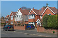
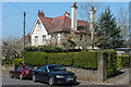
Furzefield Road
A road first developed in the early 20th Century, mainly on the northern side, with only a couple of houses on the southern side initially but with further additions over the years, as here.
Image: © Ian Capper
Taken: 19 Apr 2021
0.03 miles
2
Furzefield Road
A very different style of road from Cornfield Road, off which Furzefield Road runs (see Image).
Image: © Ian Capper
Taken: 26 Jul 2009
0.04 miles
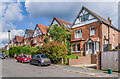
3
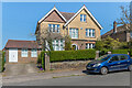
13 Furzefield Road
A road first developed in the early 20th Century, mainly on the northern side, with only a couple of houses on the southern side initially but with further additions over the years. Maps suggest that this one, now no.13 but marked as no.1 on the 1961-2 1:1,250 map, is one of the two original buildings.
Image: © Ian Capper
Taken: 19 Apr 2021
0.04 miles
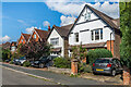
4
17 and 13 Furzefield Road
A road first developed in the early 20th Century, mainly on the northern side, with only a couple of houses on the southern side initially but with further additions over the years. Maps suggest that these two, now nos.17 (nearest) and 13 but marked as nos.1 and 3 respectively on the 1961-2 1:1,250 map, were among the earliest, with no 13 being one of the initial two buildings and no 17 following in the c.1920s.
Image: © Ian Capper
Taken: 19 Apr 2021
0.05 miles
5
17 Furzefield Road
A road first developed in the early 20th Century, mainly on the northern side, with only a couple of houses on the southern side initially but with further additions over the years. Maps suggest that this one, now no.17 but marked as no.1 on the 1961-2 1:1,250 map, dates from the c.1920s.
Image: © Ian Capper
Taken: 19 Apr 2021
0.05 miles
6
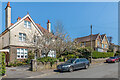
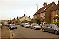
Belmont Road
Early 20th Century houses in Belmont Road.
Image: © Ian Capper
Taken: 14 Jul 2021
0.07 miles
7
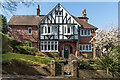
Cronks House
Early 20th Century house on Chart Lane, marked on the 1914 1:2,500 map.
Image: © Ian Capper
Taken: 19 Apr 2021
0.08 miles
8
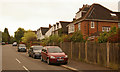
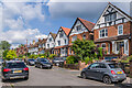
Cornfield Road
Built around 1900. Compare http://www.francisfrith.com/reigate/photos/cornfield-road-1910_62760/ for a 1910 photo from around the same spot. The road off on the right is Furzefield Road. In the background are the North Downs, with the TV mast on Reigate Hill just visible to the left of the telegraph pole.
Image: © Ian Capper
Taken: 26 Jul 2009
0.08 miles
9
Belmont Road
Early 20th Century houses in Belmont Road.
Image: © Ian Capper
Taken: 31 Aug 2020
0.08 miles
10
Belmont Road
Early 20th Century houses in Belmont Road.
Image: © Ian Capper
Taken: 14 Jul 2021
0.08 miles