IMAGES TAKEN NEAR TO
High Trees Road, REIGATE, RH2 7EN
Introduction
This page details the photographs taken nearby to High Trees Road, RH2 7EN by members of the Geograph project.
The Geograph project started in 2005 with the aim of publishing, organising and preserving representative images for every square kilometre of Great Britain, Ireland and the Isle of Man.

There are currently over 7.5m images from over14,400 individuals and you can help contribute to the project by visiting https://www.geograph.org.uk
Image Map
Images are licensed for reuse under creativecommons.org/licenses/by-sa/2.0
Notes
- Clicking on the map will re-center to the selected point.
- The higher the marker number, the further away the image location is from the centre of the postcode.
Image Listing (68 Images Found)
Images are licensed for reuse under creativecommons.org/licenses/by-sa/2.0
Image
Details
Distance
1
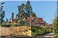
The Old House
Mainly 17th Century house in High Trees Road. Grade II listed - see www.historicengland.org.uk/listing/the-list/list-entry/1442831.
Image: © Ian Capper
Taken: 19 Apr 2021
0.00 miles
2
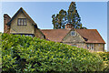
The Old House
Mainly 17th Century house in High Trees Road. Grade II listed - see www.historicengland.org.uk/listing/the-list/list-entry/1442831.
Image: © Ian Capper
Taken: 19 Apr 2021
0.00 miles
3
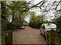
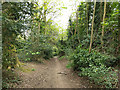
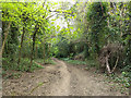
High Trees Road, Redhill
A residential byway viewed through the gate to Redhill Common.
Image: © Robin Webster
Taken: 21 Apr 2018
0.02 miles
4
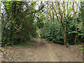
Path north up edge of Redhill Common
The common boundary is on the left.
Image: © Robin Webster
Taken: 21 Apr 2018
0.05 miles
5
Path south down edge of Redhill Common
The common boundary is on the right.
Image: © Robin Webster
Taken: 21 Apr 2018
0.05 miles
6
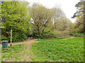
Paths, Redhill Common
Radiating from the access point at the end of High Trees Road.
Image: © Robin Webster
Taken: 21 Apr 2018
0.06 miles
7
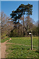
Redhill Common
A signpost on the edge of Redhill Common, near the entrance off High Trees Road. For close up and explanation of the stone in the left background, see Image
Image: © Ian Capper
Taken: 1 Apr 2012
0.06 miles
8
Redhill Common
A footpath on Redhill Common, linking the High Trees Road entrance with Whitepost Hill.
In 1862 this part of the common was compulsory purchased with a view to using it as a military prison. The proposed development never happened, but some of the stones marking the corners of the site remain, as seen here.
Image: © Ian Capper
Taken: 1 Apr 2012
0.07 miles
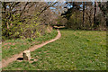
9
Path south down edge of Redhill Common
The common boundary is on the right.
Image: © Robin Webster
Taken: 21 Apr 2018
0.09 miles
10
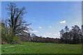
Redhill Common
The grassy are of Redhill Common. In the background is the George V memorial (see Image).
Image: © Ian Capper
Taken: 1 Apr 2012
0.09 miles