IMAGES TAKEN NEAR TO
Belmont Road, REIGATE, RH2 7ED
Introduction
This page details the photographs taken nearby to Belmont Road, RH2 7ED by members of the Geograph project.
The Geograph project started in 2005 with the aim of publishing, organising and preserving representative images for every square kilometre of Great Britain, Ireland and the Isle of Man.

There are currently over 7.5m images from over14,400 individuals and you can help contribute to the project by visiting https://www.geograph.org.uk
Image Map
Images are licensed for reuse under creativecommons.org/licenses/by-sa/2.0
Notes
- Clicking on the map will re-center to the selected point.
- The higher the marker number, the further away the image location is from the centre of the postcode.
Image Listing (149 Images Found)
Images are licensed for reuse under creativecommons.org/licenses/by-sa/2.0
Image
Details
Distance
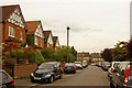
1
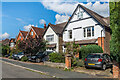
Belmont Road
Early 20th Century houses in Belmont Road.
Image: © Ian Capper
Taken: 31 Aug 2020
0.02 miles
2
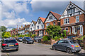
Belmont Road
Early 20th Century houses in Belmont Road.
Image: © Ian Capper
Taken: 14 Jul 2021
0.03 miles
3
Belmont Road
Early 20th Century houses in Belmont Road. The nearest one has a date plaque of 1908.
Image: © Ian Capper
Taken: 31 Aug 2020
0.03 miles
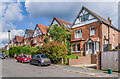
4
Belmont Road
Early 20th Century houses in Belmont Road. Both these seen here have date plaques of 1907.
Image: © Ian Capper
Taken: 31 Aug 2020
0.04 miles
5
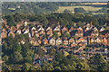
Chart Lane from Reigate Hill
Looking towards the Chart Lane area of Reigate from Reigate Hill. The prominent line of houses across the centre of the photo are in Chart Lane itself, with Belmont Road beyond and Furzefield Road below the line of trees on the top of the ridge.
Image: © Ian Capper
Taken: 29 Jun 2018
0.04 miles
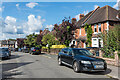
6
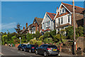
Chart Lane
Turn of 19th/20th Century housing on Chart Lane.
Image: © Ian Capper
Taken: 3 Aug 2018
0.04 miles
7
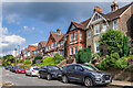
Chart Lane
Turn of 19th/20th Century housing on Chart Lane.
Image: © Ian Capper
Taken: 14 Jul 2021
0.04 miles
8
Belmont Road
Early 20th Century houses in Belmont Road.
Image: © Ian Capper
Taken: 14 Jul 2021
0.04 miles
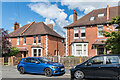
9
Belmont Road
Built around 1900. In the background is Cornfield Road.
Image: © Ian Capper
Taken: 26 Jul 2009
0.04 miles
10
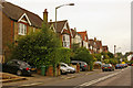
Chart Lane
Early 20th century housing on a stretch on Chart Lane that once formed part of a much older east-west route, which included Smoke Lane (see Image).
Image: © Ian Capper
Taken: 26 Jul 2009
0.04 miles