IMAGES TAKEN NEAR TO
Chart Lane, REIGATE, RH2 7DZ
Introduction
This page details the photographs taken nearby to Chart Lane, RH2 7DZ by members of the Geograph project.
The Geograph project started in 2005 with the aim of publishing, organising and preserving representative images for every square kilometre of Great Britain, Ireland and the Isle of Man.

There are currently over 7.5m images from over14,400 individuals and you can help contribute to the project by visiting https://www.geograph.org.uk
Image Map
Images are licensed for reuse under creativecommons.org/licenses/by-sa/2.0
Notes
- Clicking on the map will re-center to the selected point.
- The higher the marker number, the further away the image location is from the centre of the postcode.
Image Listing (230 Images Found)
Images are licensed for reuse under creativecommons.org/licenses/by-sa/2.0
Image
Details
Distance
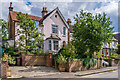
1
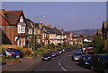
Chart Lane
Late Victorian housing.
Chart is a name that crops up in a number of places in Kent and Surrey, in the context of the lower greensand ridge that runs south of the North Downs, and Chart Lane, leading as it does over this ridge, would seem to fit in with this definition.
In the background are the North Downs to the west of Colley Hill. The office building in the middle distance is The Observatory (see Image).
Image: © Ian Capper
Taken: 21 Mar 2009
0.01 miles
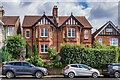
2
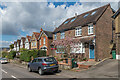
Chart Lane
c.1910s/20s houses in Chart Lane, with the semi-detached pair of nos 47 - 49 nearest.
Image: © Ian Capper
Taken: 12 Apr 2021
0.02 miles
3
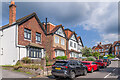
Chart Lane
c.1910s houses in Chart Lane, with no 55 nearest.
Image: © Ian Capper
Taken: 14 Jul 2021
0.03 miles
4
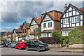
Chart Lane
c.1910s/20s houses in Chart Lane, with no 61 nearest.
Image: © Ian Capper
Taken: 12 Apr 2021
0.03 miles
5
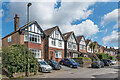
Chart Lane
Row of c.1910s/20s houses in Chart Lane, with no 33 nearest.
Image: © Ian Capper
Taken: 12 Apr 2021
0.03 miles
6
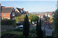
Outlook on Chart Lane
Behind the trees, Chart Lane descends towards the centre of Reigate. In the background is Reigate Hill and the escarpment of the North Downs.
Image: © Bill Boaden
Taken: 11 Nov 2016
0.04 miles
7
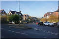
Chart Lane
A bit further up the hill where there is mature housing, much of it subdivided into flats. That of course puts pressure on the parking.
Image: © Bill Boaden
Taken: 11 Nov 2016
0.04 miles
8
Cockshot Road
Semi-detached early 20th century houses, with some ornate brickwork.
Image: © Ian Capper
Taken: 26 Jul 2009
0.05 miles
9
4 Cockshot Road
Turn of the 19th/20th Century house on Cockshot Road.
Image: © Ian Capper
Taken: 14 Jul 2021
0.05 miles
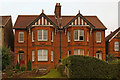
10
66 & 68 Chart Lane
Pair of semi-detached houses in Chart Lane, dating from the c.early 20th Century, situated by its junction with Cockshot Road, no 2 Cockshot Road being the house on the far right of the photo.
Image: © Ian Capper
Taken: 14 Jul 2021
0.05 miles