IMAGES TAKEN NEAR TO
Bell Street, REIGATE, RH2 7BA
Introduction
This page details the photographs taken nearby to Bell Street, RH2 7BA by members of the Geograph project.
The Geograph project started in 2005 with the aim of publishing, organising and preserving representative images for every square kilometre of Great Britain, Ireland and the Isle of Man.

There are currently over 7.5m images from over14,400 individuals and you can help contribute to the project by visiting https://www.geograph.org.uk
Image Map
Images are licensed for reuse under creativecommons.org/licenses/by-sa/2.0
Notes
- Clicking on the map will re-center to the selected point.
- The higher the marker number, the further away the image location is from the centre of the postcode.
Image Listing (894 Images Found)
Images are licensed for reuse under creativecommons.org/licenses/by-sa/2.0
Image
Details
Distance
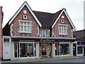
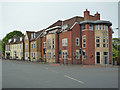
1
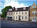
38/40 Bell Street
Early 18th century grade II listed building. For listing particulars see www.historicengland.org.uk/listing/the-list/list-entry/1029137. On the left is the entrance to Bell Street car park, through part of the grade 1c listed Priory Park wall (see Image).
Image: © Ian Capper
Taken: 3 May 2009
0.00 miles
2
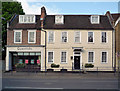
38/40 Bell Street
Early 18th century grade II listed building. For listing particulars see www.historicengland.org.uk/listing/the-list/list-entry/1029137.
Image: © Ian Capper
Taken: 3 May 2009
0.00 miles
4
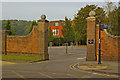
Exit from Bell Street car park
Redesigned in 2008 as part of the refurbishment of Priory Park. In the background is Reigate Priory.
Image: © Ian Capper
Taken: 26 Jul 2009
0.01 miles
5
41 Bell Street
Grade II building dating from the mid/late 19th century - for listing particulars see www.historicengland.org.uk/listing/the-list/list-entry/1029132.
Image: © Ian Capper
Taken: 3 May 2009
0.01 miles
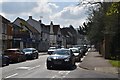
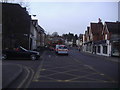
6
Bell Street at the junction of Bancroft Road, Reigate
Image: © David Howard
Taken: 10 Dec 2012
0.02 miles
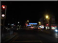
7
A217 Bell Street
Approaching Reigate town centre and one way system.
Image: © David Howard
Taken: 15 Mar 2009
0.02 miles
8
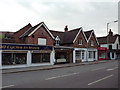
45a - 47a Bell Street
Late 19th century locally listed building
Image: © Ian Capper
Taken: 3 May 2009
0.02 miles
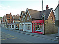
9
34 - 40 Bell Street
34 and 36 (the modern buildings nearest the camera are a recent build, when the route to what was originally Safeways (now Morrisons) was built. The far two buildings, 38 and 40, are much older - see Image
Image: © Ian Capper
Taken: 4 May 2009
0.02 miles
10
45a - 47a Bell Street
Late 19th century locally listed building
Image: © Ian Capper
Taken: 3 May 2009
0.02 miles