IMAGES TAKEN NEAR TO
High Road, Upper Gatton, REIGATE, RH2 0TZ
Introduction
This page details the photographs taken nearby to High Road, Upper Gatton, RH2 0TZ by members of the Geograph project.
The Geograph project started in 2005 with the aim of publishing, organising and preserving representative images for every square kilometre of Great Britain, Ireland and the Isle of Man.

There are currently over 7.5m images from over14,400 individuals and you can help contribute to the project by visiting https://www.geograph.org.uk
Image Map (Loading...)


Getting Data...Please wait
Leaflet Map data © OpenStreetMap
Images are licensed for reuse under creativecommons.org/licenses/by-sa/2.0
Notes
- Clicking on the map will re-center to the selected point.
- The higher the marker number, the further away the image location is from the centre of the postcode.
Image Listing (5 Images Found)
Images are licensed for reuse under creativecommons.org/licenses/by-sa/2.0
Image
Details
Distance
1
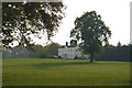
View Towards Upper Gatton Park
Looking across the parkland, towards the house at Upper Gatton Park.
Image: © Peter Trimming
Taken: 30 Oct 2009
0.12 miles
2
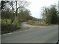
Fair Lane near Mugswell
Fair lane at the junction with High Road.
Image: © John Hilton
Taken: 12 Mar 2007
0.16 miles
3
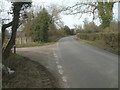
High Road at the junction with Fair Lane
A view of High Road looking NE at its junction with Fair Lane.
Image: © John Hilton
Taken: 12 Mar 2007
0.17 miles
4
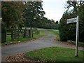
North carriage drive to Upper Gatton Park
The north carriage drive to Upper Gatton Park from High Road, now the principal access.
Image: © Hugh Craddock
Taken: 19 Oct 2008
0.24 miles
5
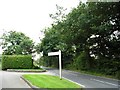
High Road at the entrance to Upper Gatton Park, Mugswell
Image: © David Howard
Taken: 9 Sep 2012
0.24 miles