IMAGES TAKEN NEAR TO
Gatton Park Road, REIGATE, RH2 0SX
Introduction
This page details the photographs taken nearby to Gatton Park Road, RH2 0SX by members of the Geograph project.
The Geograph project started in 2005 with the aim of publishing, organising and preserving representative images for every square kilometre of Great Britain, Ireland and the Isle of Man.

There are currently over 7.5m images from over14,400 individuals and you can help contribute to the project by visiting https://www.geograph.org.uk
Image Map
Images are licensed for reuse under creativecommons.org/licenses/by-sa/2.0
Notes
- Clicking on the map will re-center to the selected point.
- The higher the marker number, the further away the image location is from the centre of the postcode.
Image Listing (20 Images Found)
Images are licensed for reuse under creativecommons.org/licenses/by-sa/2.0
Image
Details
Distance
1
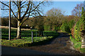
Track by Lodge Farm, Gatton
Located on the southern edge of the Gatton Park Estate.
Image: © Peter Trimming
Taken: 20 Dec 2013
0.07 miles
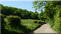
3
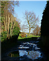
Wet Bridleway at Gatton Park
Taken from close to Nutwood Farm, on the right, and Nut Wood, on the left.
Image: © Peter Trimming
Taken: 20 Dec 2013
0.17 miles
4
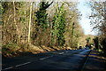
Gatton Park Road, Coles Mead
Looking down the A242, which links Reigate to Merstham. Gatton Park lies to the left of picture.
Image: © Peter Trimming
Taken: 20 Dec 2013
0.17 miles
5
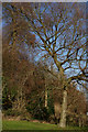
Tree in Gatton Park
A lone tree, standing in front of Nut Wood, in the National Trust portion of the estate.
Image: © Peter Trimming
Taken: 20 Dec 2013
0.17 miles
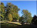
6
Nut Wood in Gatton Park
Nut Wood lies to the left of picture, in the National Trust portion of the estate.
Image: © Peter Trimming
Taken: 20 Dec 2013
0.18 miles
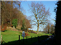
7
Trees by Gatton Wood
Taken from bridleway 76 where, having climbed from West Lodge, it begins a descent across the park.
Image: © Derek Harper
Taken: 15 Oct 2011
0.18 miles
8
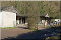
Nutwood Farm stables
Stables at Nutwood Farm, on the track that leads from Gatton Park Road to Gatton.
Image: © Ian Capper
Taken: 19 Mar 2011
0.19 miles
9
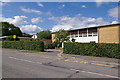
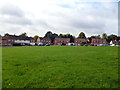
St Bede's School
A joint Church of England and Roman Catholic secondary school, founded in 1976 following the merger of the St Joseph’s RC Secondary School and Bishop Simpson Church of England Girls’ School.
Image: © Ian Capper
Taken: 17 Jul 2010
0.20 miles
10
Bridleway, Gatton Park
View along the bridleway, with Nut Wood to the left.
Image: © Peter Trimming
Taken: 24 May 2009
0.20 miles