IMAGES TAKEN NEAR TO
Castlefield Road, REIGATE, RH2 0SD
Introduction
This page details the photographs taken nearby to Castlefield Road, RH2 0SD by members of the Geograph project.
The Geograph project started in 2005 with the aim of publishing, organising and preserving representative images for every square kilometre of Great Britain, Ireland and the Isle of Man.

There are currently over 7.5m images from over14,400 individuals and you can help contribute to the project by visiting https://www.geograph.org.uk
Image Map
Images are licensed for reuse under creativecommons.org/licenses/by-sa/2.0
Notes
- Clicking on the map will re-center to the selected point.
- The higher the marker number, the further away the image location is from the centre of the postcode.
Image Listing (657 Images Found)
Images are licensed for reuse under creativecommons.org/licenses/by-sa/2.0
Image
Details
Distance
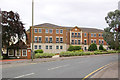
1
Reigate College
Originally Reigate County School for Girls, it is now a sixth form college. It was designed by architects Jarvis and Porter and opened in 1927.
Image: © Ian Capper
Taken: 4 May 2009
0.01 miles
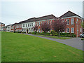
2
Reigate College
Originally Reigate County School for Girls, it has since 1977 been a sixth form college, with much building expansion taking place over the years.
Image: © Ian Capper
Taken: 7 Dec 2013
0.03 miles
3
Reigate College
Originally Reigate County School for Girls, it has since 1977 been a sixth form college, with much building expansion taking place over the years.
Image: © Ian Capper
Taken: 18 Apr 2022
0.04 miles
4
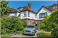
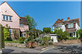
South Walk
Houses in South Walk, a road developed in the c.1920s following the demolition of Reigate Lodge.
Image: © Ian Capper
Taken: 15 May 2020
0.07 miles
5
South Walk
Houses in South Walk, a road developed in the c.1920s following the demolition of Reigate Lodge.
Image: © Ian Capper
Taken: 15 May 2020
0.07 miles
6
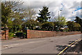
Church Street
These walls and gates originally belonged to Reigate Lodge, a large 18th century mansion, the lodge to which was situated at this entrance. The house was demolished in the 1920s and the land used for what is now Reigate College (see Image) and housing, for example Rushworth Road (see Image). However the surrounding walls and shrubbery were retained, giving some privacy to the houses built immediately behind them, here South Walk.
The wall is locally listed.
Image: © Ian Capper
Taken: 21 Apr 2012
0.07 miles
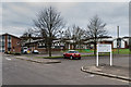
7
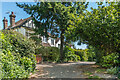
18 & 20 The Crescent
Houses in The Crescent, a road developed in the c.1920s following the demolition of Reigate Lodge. Although separately named, the numbering in this road is continuous with that of the neighbouring Chart Way, off which it forms a short loop. However the 1963-4 1:2,500 marks the houses in both roads with names: Chart for no 20 (nearest) and Glen Goyt for no 18.
Image: © Ian Capper
Taken: 15 May 2020
0.07 miles
9
Reigate : Church Street
Looking along Church Street as it heads into the centre of Reigate.
Image: © Lewis Clarke
Taken: 6 Jul 2014
0.07 miles
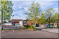
10
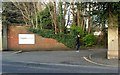
Castlefield House
Offices in Castlefield Road.
Image: © Ian Capper
Taken: 5 Jul 2009
0.08 miles