IMAGES TAKEN NEAR TO
Lorian Drive, REIGATE, RH2 0NU
Introduction
This page details the photographs taken nearby to Lorian Drive, RH2 0NU by members of the Geograph project.
The Geograph project started in 2005 with the aim of publishing, organising and preserving representative images for every square kilometre of Great Britain, Ireland and the Isle of Man.

There are currently over 7.5m images from over14,400 individuals and you can help contribute to the project by visiting https://www.geograph.org.uk
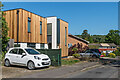
Image Map
Images are licensed for reuse under creativecommons.org/licenses/by-sa/2.0
Notes
- Clicking on the map will re-center to the selected point.
- The higher the marker number, the further away the image location is from the centre of the postcode.
Image Listing (108 Images Found)
Images are licensed for reuse under creativecommons.org/licenses/by-sa/2.0
Image
Details
Distance
1
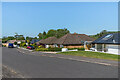
Wrayfield Avenue
Cul-de-sac off Wray Common Road dating from the c.1960s using land at the rear of a large Victorian house named Wrayfield.
Image: © Ian Capper
Taken: 15 May 2020
0.03 miles
2
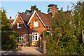
Mansefield Cottage, 142 Croydon Road
A former bakery dating from the early 19th century - note the combination of stone, brick and tile frontage.
Image: © Ian Capper
Taken: 27 May 2012
0.04 miles
3
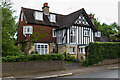
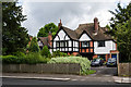
51 Croydon Road
One of a number of "Arts and Crafts" houses in Croydon Road, this one dating from 1906, designed by architect T P Figgis. Locally listed.
Image: © Ian Capper
Taken: 15 Jun 2013
0.04 miles
4
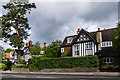
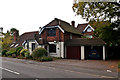
Croydon Road
"Arts and Crafts" houses in Croydon Road. On the right is no.51, dating from 1906, designed by architect T P Figgis. Locally listed.
Image: © Ian Capper
Taken: 15 Jun 2013
0.05 miles
5
45 Croydon Road
One of a number of "Arts and Crafts" houses in Croydon Road.
Image: © Ian Capper
Taken: 15 Jun 2013
0.06 miles
6
Wilmots Close
A 1960s cul-de-sac off Doods Road.
Image: © Ian Capper
Taken: 15 May 2020
0.08 miles
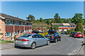
8
Wraymead Lodge
Lodge to Wraymead, the large house in the background, built in the late 19th century.
Image: © Ian Capper
Taken: 7 Oct 2012
0.10 miles
9
Wilmots Close
A 1960s cul-de-sac off Doods Road. The nearest house, no. 1, was originally a bungalow, significantly extended in 2019.
Image: © Ian Capper
Taken: 15 May 2020
0.10 miles
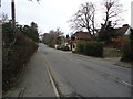
10
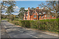
Wray Common Road
Looking along Wray Common Road to Wray Common itself. On the right is Wray Coppice, a large late Victorian mansion, later used as offices of Osborne, the building company, but since converted into flats.
Image: © Ian Capper
Taken: 12 Apr 2021
0.10 miles