
IMAGES TAKEN NEAR TO
Tree Way, REIGATE, RH2 0DT
Introduction
This page details the photographs taken nearby to Tree Way, RH2 0DT by members of the Geograph project.
The Geograph project started in 2005 with the aim of publishing, organising and preserving representative images for every square kilometre of Great Britain, Ireland and the Isle of Man.

There are currently over 7.5m images from over14,400 individuals and you can help contribute to the project by visiting https://www.geograph.org.uk
Image Map
Images are licensed for reuse under creativecommons.org/licenses/by-sa/2.0
Notes
- Clicking on the map will re-center to the selected point.
- The higher the marker number, the further away the image location is from the centre of the postcode.
Image Listing (79 Images Found)
Images are licensed for reuse under creativecommons.org/licenses/by-sa/2.0
Image
Details
Distance
1
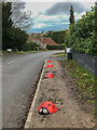
Ladybird bollards
A novel variation on the usual logs or rocks used to stop verge parking. This is Ragland Road, near its junction with Alma Road. The postbox in the background is the "anonymous" postbox in Image
Image: © Ian Capper
Taken: 2 Jan 2021
0.07 miles
2
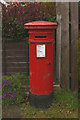
Anonymous postbox, Raglan Road
Postboxes usually prove their "royal" status by including the initials of the monarch of the time on the front. This one is anonymous, a particular feature of boxes dated between 1879 and 1887 manufactured by the firm Handyside during this period. The positioning of the aperture implies that this box dates from 1883 onwards, earlier ones having the aperture positioned higher up (e.g. see Image).
For wider view see Image
Image: © Ian Capper
Taken: 19 Apr 2008
0.08 miles
3
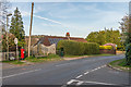
Raglan Road
Looking along Raglan Road from its junction with Alma Road. On the left is the "anonymous postbox" in Image
Image: © Ian Capper
Taken: 7 Apr 2020
0.09 miles
4
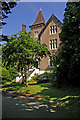
Undercroft, Raglan Road
A large locally listed house dating from the mid 19th century, one of a number from that period as the southern slopes of Reigate Hill were developed as a fashionable place to live. It is now divided into flats.
At the end of the 19th century the residents were recorded as James Backhouse Crosfields (a tea dealer, quaker and ornithologist, who had served two terms as President of the Holmesdale Natural History Club - see Image), Herbert Crosfield and a Miss Crosfield. In 1913, a Miss Crosfield is still recorded as living there, with reference to her being a suffragette.
Image: © Ian Capper
Taken: 7 Jun 2008
0.09 miles
5
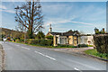
Wray Park Lodge
Lodge to Wray Park Hall in Alma Road (see Image). Built in the mid 19th Century it is grade II listed - see www.historicengland.org.uk/listing/the-list/list-entry/1029170 - with the gate piers being separately grade II listed - see www.historicengland.org.uk/listing/the-list/list-entry/1029171.
In the background is Raglan Road - the postbox visible is the "anonymous" postbox in Image
Image: © Ian Capper
Taken: 7 Apr 2020
0.11 miles
6
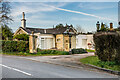
Wray Park Lodge
Lodge to Wray Park Hall in Alma Road (see Image). Built in the mid 19th Century it is grade II listed - see www.historicengland.org.uk/listing/the-list/list-entry/1029170 - with the gate piers being separately grade II listed - see www.historicengland.org.uk/listing/the-list/list-entry/1029171.
Image: © Ian Capper
Taken: 7 Apr 2020
0.11 miles
7
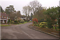
Friths Drive
See Image] for background. This is the upper part of the road.
Image: © Ian Capper
Taken: 20 Apr 2008
0.11 miles
8
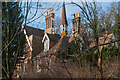
The Rock, Reigate Hill
Part of a Victorian mansion on Reigate Hill, dating from around 1840, viewed through trees screening it from the main road. Now divided into 3 flats. Locally listed.
Image: © Ian Capper
Taken: 21 Jan 2012
0.12 miles
9
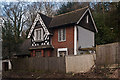
Rock Cottage
Dating from around 1840, this and its partner, Highway Cottage, stand at the entrance to The Rock, a large house on Reigate Hill (see Image). Rock Cottage is locally listed.
Image: © Ian Capper
Taken: 21 Jan 2012
0.13 miles
10
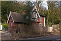
Rock Cottage
Dating from around 1840, this and its partner, Highway Cottage, stand at the entrance to The Rock, a large house on Reigate Hill (see Image). Rock Cottage is locally listed.
Image: © Ian Capper
Taken: 21 Jan 2012
0.13 miles