IMAGES TAKEN NEAR TO
Crowhurst Crescent, PULBOROUGH, RH20 4QU
Introduction
This page details the photographs taken nearby to Crowhurst Crescent, RH20 4QU by members of the Geograph project.
The Geograph project started in 2005 with the aim of publishing, organising and preserving representative images for every square kilometre of Great Britain, Ireland and the Isle of Man.

There are currently over 7.5m images from over14,400 individuals and you can help contribute to the project by visiting https://www.geograph.org.uk
Image Map
Images are licensed for reuse under creativecommons.org/licenses/by-sa/2.0
Notes
- Clicking on the map will re-center to the selected point.
- The higher the marker number, the further away the image location is from the centre of the postcode.
Image Listing (5 Images Found)
Images are licensed for reuse under creativecommons.org/licenses/by-sa/2.0
Image
Details
Distance
1
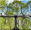
Spikes on a pipe over the stream
These are presumably to stop children climbing over the pipe - except that children don't do that sort of thing these days!
Image: © Ian Hawfinch
Taken: 11 May 2023
0.07 miles
2
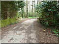
Bridge over stream on what was once Fryern Hall land
Fryern Hall was demolished in 1965.
Image: © Dave Spicer
Taken: 2 Apr 2011
0.21 miles
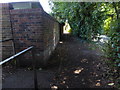
3
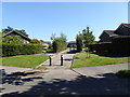
Access path to Faithfull Crescent
The camera is in Hurston Lane.
Image: © Shazz
Taken: 22 Aug 2015
0.23 miles
4
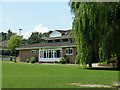
Pavilion, Storrington Cricket Club
This is right next to the small leisure centre building, to the right of the willow.
Image: © Robin Webster
Taken: 23 Jun 2011
0.23 miles
5
Junction of twitten and pavement on Hurston Lane
Image: © Shazz
Taken: 22 Aug 2015
0.25 miles