IMAGES TAKEN NEAR TO
Hormare Crescent, PULBOROUGH, RH20 4HU
Introduction
This page details the photographs taken nearby to Hormare Crescent, RH20 4HU by members of the Geograph project.
The Geograph project started in 2005 with the aim of publishing, organising and preserving representative images for every square kilometre of Great Britain, Ireland and the Isle of Man.

There are currently over 7.5m images from over14,400 individuals and you can help contribute to the project by visiting https://www.geograph.org.uk
Image Map (6 Images)


Getting Data...Please wait
Leaflet Map data © OpenStreetMap
Images are licensed for reuse under creativecommons.org/licenses/by-sa/2.0
Notes
- Clicking on the map will re-center to the selected point.
- The higher the marker number, the further away the image location is from the centre of the postcode.
Image Listing (6 Images Found)
Images are licensed for reuse under creativecommons.org/licenses/by-sa/2.0
Image
Details
Distance
1
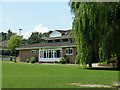
Pavilion, Storrington Cricket Club
This is right next to the small leisure centre building, to the right of the willow.
Image: © Robin Webster
Taken: 23 Jun 2011
0.10 miles
3
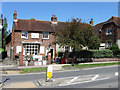
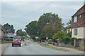
Stable Antiques, West Street
A shop on the western side of the village. The footpath on the left leads to North Street.
Image: © Simon Carey
Taken: 30 May 2009
0.20 miles
4
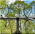
Spikes on a pipe over the stream
These are presumably to stop children climbing over the pipe - except that children don't do that sort of thing these days!
Image: © Ian Hawfinch
Taken: 11 May 2023
0.22 miles
6
Looking across road junction from one twitten to another
For a different angle see http://www.geograph.org.uk/photo/2345860.
Image: © Shazz
Taken: 28 Aug 2015
0.25 miles