IMAGES TAKEN NEAR TO
Hurston Grove, PULBOROUGH, RH20 4HQ
Introduction
This page details the photographs taken nearby to Hurston Grove, RH20 4HQ by members of the Geograph project.
The Geograph project started in 2005 with the aim of publishing, organising and preserving representative images for every square kilometre of Great Britain, Ireland and the Isle of Man.

There are currently over 7.5m images from over14,400 individuals and you can help contribute to the project by visiting https://www.geograph.org.uk
Image Map (Loading...)


Getting Data...Please wait
Leaflet Map data © OpenStreetMap
Images are licensed for reuse under creativecommons.org/licenses/by-sa/2.0
Notes
- Clicking on the map will re-center to the selected point.
- The higher the marker number, the further away the image location is from the centre of the postcode.
Image Listing (13 Images Found)
Images are licensed for reuse under creativecommons.org/licenses/by-sa/2.0
Image
Details
Distance
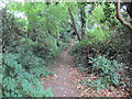
1
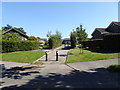
Access path to Faithfull Crescent
The camera is in Hurston Lane.
Image: © Shazz
Taken: 22 Aug 2015
0.06 miles
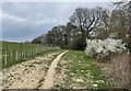
2
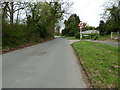
North on Hurston Lane
Hurston Lane runs off the A283 at Cootham, to Hurston Place, and then loops around to rejoin the A283 at Bog Common.
Image: © Dave Spicer
Taken: 2 Apr 2011
0.09 miles
3
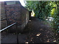
Junction of twitten and pavement on Hurston Lane
Image: © Shazz
Taken: 22 Aug 2015
0.10 miles
5
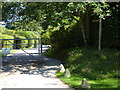
Route to Hurston Lane
Public footpath 2645.
Image: © Peter Holmes
Taken: 20 Jul 2013
0.16 miles
7
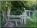
Stile on footpath making for Hurston Lane
The stile has been improved since http://www.geograph.org.uk/photo/3573481.
Image: © Shazz
Taken: 22 Aug 2015
0.18 miles
8
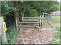
Dilapidated stile
Stile in unstable condition on public footpath 2645.
Image: © Peter Holmes
Taken: 20 Jul 2013
0.18 miles
9
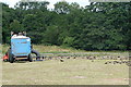
Poo vac at work
The man was driving his small tractor towing a collector with a suction attachment that was picking up all the horse dung from the paddock. There was lots of it.
Image: © Graham Horn
Taken: 1 Aug 2010
0.19 miles
10
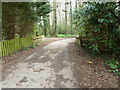
Bridge over stream on what was once Fryern Hall land
Fryern Hall was demolished in 1965.
Image: © Dave Spicer
Taken: 2 Apr 2011
0.20 miles