IMAGES TAKEN NEAR TO
The Glebe, PULBOROUGH, RH20 4FR
Introduction
This page details the photographs taken nearby to The Glebe, RH20 4FR by members of the Geograph project.
The Geograph project started in 2005 with the aim of publishing, organising and preserving representative images for every square kilometre of Great Britain, Ireland and the Isle of Man.

There are currently over 7.5m images from over14,400 individuals and you can help contribute to the project by visiting https://www.geograph.org.uk
Image Map
Images are licensed for reuse under creativecommons.org/licenses/by-sa/2.0
Notes
- Clicking on the map will re-center to the selected point.
- The higher the marker number, the further away the image location is from the centre of the postcode.
Image Listing (139 Images Found)
Images are licensed for reuse under creativecommons.org/licenses/by-sa/2.0
Image
Details
Distance
1
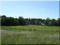
Fields behind West Street
This bucolic view may seem to belong to the open countryside but is actually enclosed within the centre of Storrington by West Street to the north, School Lane to the south, Monastery Lane to the west and Church Street to the east. Prior to 1841 this view would have looked onto the old Storrington Common.
Image: © Simon Carey
Taken: 30 May 2009
0.04 miles
4
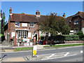
Stable Antiques, West Street
A shop on the western side of the village. The footpath on the left leads to North Street.
Image: © Simon Carey
Taken: 30 May 2009
0.07 miles
5
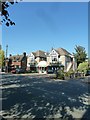
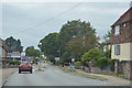
Looking across the High Street towards the entrance to the bowling club
Image: © Basher Eyre
Taken: 29 Sep 2011
0.08 miles
6
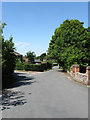
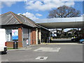
Monastery Lane
Heading north from the junction of Kithurst Lane and School Lane towards West Street. Fern Road is on the left.
Image: © Simon Carey
Taken: 30 May 2009
0.09 miles
7
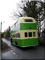
Old Southdown bus heading along Monastery Lane
Image: © Basher Eyre
Taken: 20 Mar 2010
0.09 miles
8
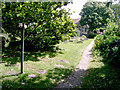
Footpath near St Mary's Church, Storrington
The path runs through the churchyard; some headstones can be seen in the picture.
Image: © Slbs
Taken: 25 Jun 2008
0.09 miles
9
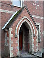
Entrance to the presbytery in School Lane
Image: © Basher Eyre
Taken: 20 Mar 2010
0.10 miles
10
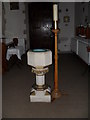
The font within Our Lady of England, Storrington
Image: © Basher Eyre
Taken: 20 Mar 2010
0.10 miles