IMAGES TAKEN NEAR TO
Pay Gate, London Road, PULBOROUGH, RH20 4DL
Introduction
This page details the photographs taken nearby to Pay Gate, London Road, RH20 4DL by members of the Geograph project.
The Geograph project started in 2005 with the aim of publishing, organising and preserving representative images for every square kilometre of Great Britain, Ireland and the Isle of Man.

There are currently over 7.5m images from over14,400 individuals and you can help contribute to the project by visiting https://www.geograph.org.uk
Image Map (Loading...)


Getting Data...Please wait
Leaflet Map data © OpenStreetMap
Images are licensed for reuse under creativecommons.org/licenses/by-sa/2.0
Notes
- Clicking on the map will re-center to the selected point.
- The higher the marker number, the further away the image location is from the centre of the postcode.
Image Listing (60 Images Found)
Images are licensed for reuse under creativecommons.org/licenses/by-sa/2.0
Image
Details
Distance
1
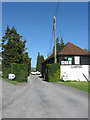
Entrance to Washington Park
An old barn has been utilised as an office for a camping and caravan park.
Image: © Simon Carey
Taken: 6 May 2013
0.06 miles
2
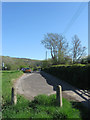
Old Course of London Road
The road's junction with The Pike, the A283, was rerouted in the late 1960s when the new course of the A24 was made to the west. This remaining section is now a car park.
Image: © Simon Carey
Taken: 6 May 2013
0.08 miles
3
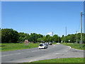
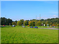
Washington Roundabout
Opened in 1968 along with the village's bypass on the site of a former 19th century brickworks. In the foreground is the junction with Sandhill Lane which was the former road junction between the A24 and A283 heading west to Storrington. The long line of traffic trying to access the A24 has just left an event at Wiston House which happened over the bank holiday weekend.
Image: © Simon Carey
Taken: 27 May 2013
0.10 miles
4
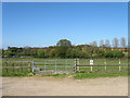
The Enhams
The name of the field according to Washington's 1839 tithe map that has now been turned into paddocks. Just visible through the trees to the right is Rock Common quarry.
Image: © Simon Carey
Taken: 6 May 2013
0.10 miles
5
Washington Roundabout
Built in 1967-68 to replace the previous staggered junction of the A24/A283 that ran through the village.
Image: © Simon Carey
Taken: 11 Oct 2008
0.10 miles
6
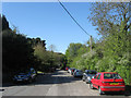
Sandhill Lane
The old course of the A24 created when the new bypass was built in the late 1960s. The lane serves a few houses and Sandhill Farm.
Image: © Simon Carey
Taken: 6 May 2013
0.11 miles
7
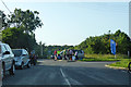
Worthing Excelsior cycling event, Washington
I can't find a scheduled event although riders were about with numbers on them. The club's weekly ride uses here as a base but that is on a Sunday. Maybe something postponed because of bad weather.
Image: © Robin Webster
Taken: 27 Jun 2019
0.11 miles
8
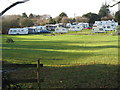
Washington camping and caravan park
A few people were using it as a Christmas holiday.
Image: © Dave Spicer
Taken: 2 Jan 2011
0.12 miles
9
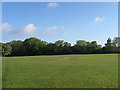
Washington Recreation Ground
Marked as such on the 1879 OS map and still in use today as both a cricket and football pitch with a small playground to the south and some tennis courts behind the village hall. The land was once part of Washington Common which was enclosed in 1851.
Image: © Simon Carey
Taken: 27 May 2013
0.12 miles
10
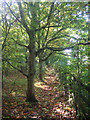
Footpath to Washington Church
The bucolic charm is somewhat tempered by the fact that beyond the fence to the right is the very busy A24. The footpath starts opposite the entrance of Washington Park on the A283 then heads north to The Street next to the church.
Image: © Simon Carey
Taken: 11 Oct 2008
0.12 miles