IMAGES TAKEN NEAR TO
Old London Road, RH20 3RJ
Introduction
This page details the photographs taken nearby to Old London Road, RH20 3RJ by members of the Geograph project.
The Geograph project started in 2005 with the aim of publishing, organising and preserving representative images for every square kilometre of Great Britain, Ireland and the Isle of Man.

There are currently over 7.5m images from over14,400 individuals and you can help contribute to the project by visiting https://www.geograph.org.uk
Image Map
Images are licensed for reuse under creativecommons.org/licenses/by-sa/2.0
Notes
- Clicking on the map will re-center to the selected point.
- The higher the marker number, the further away the image location is from the centre of the postcode.
Image Listing (40 Images Found)
Images are licensed for reuse under creativecommons.org/licenses/by-sa/2.0
Image
Details
Distance
1
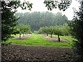
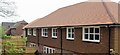
Montpelier Gardens, Rock
The land here was once part of Washington Common until enclosure in the mid 19th century. After that it was used for market gardening and after the First World War parts began to be developed such as this small estate built by the council in the 1930s.
Image: © Simon Carey
Taken: 27 May 2013
0.02 miles
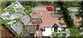
2
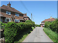
Old London Road, Rock
The former course of the A24 as it passes through the hamlet north of Washington. When Washington's bypass was built in 1964 it was also dualled north of the new roundabout bypassing the hamlet in the process. On the left is Harmston House whilst to the right is The Old Smithy which has now been converted into a restaurant.
Image: © Simon Carey
Taken: 27 May 2013
0.07 miles
3
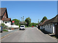
Washington House, Rock
Home to HGH Groundworks Ltd. Once part of Washington Common the entrance to the works once contained a small sand pit and after enclosure much of the land became orchards until some were developed in the 1930s though this strip was not developed until after the Second World War.
Image: © Simon Carey
Taken: 27 May 2013
0.07 miles
4
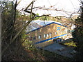
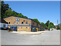
Birds eye view of industrial unit by Washington Common
Image: © Dave Spicer
Taken: 2 Jan 2011
0.08 miles
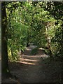
7
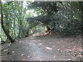
Yew and Holly, Warren Hill
Public footpath 2630 through National Trust woodland.
Image: © Peter Holmes
Taken: 20 Jul 2013
0.12 miles
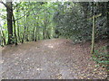
8
Footpath, Washinton Common
Heading past Image which is on the right, towards Rock. The common has been owned by the National Trust since 1935.
Image: © Simon Carey
Taken: 6 May 2013
0.12 miles
9
Fingerpost, Warren Hill
Public footpath 2630 through National Trust woodland.
Image: © Peter Holmes
Taken: 20 Jul 2013
0.12 miles