IMAGES TAKEN NEAR TO
Greenhurst Lane, PULBOROUGH, RH20 3EY
Introduction
This page details the photographs taken nearby to Greenhurst Lane, RH20 3EY by members of the Geograph project.
The Geograph project started in 2005 with the aim of publishing, organising and preserving representative images for every square kilometre of Great Britain, Ireland and the Isle of Man.

There are currently over 7.5m images from over14,400 individuals and you can help contribute to the project by visiting https://www.geograph.org.uk
Image Map
Images are licensed for reuse under creativecommons.org/licenses/by-sa/2.0
Notes
- Clicking on the map will re-center to the selected point.
- The higher the marker number, the further away the image location is from the centre of the postcode.
Image Listing (21 Images Found)
Images are licensed for reuse under creativecommons.org/licenses/by-sa/2.0
Image
Details
Distance
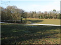
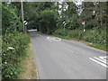
2
Footpath approaching Greenhurst Lane
Public footpath 2463/1.
Image: © Peter Holmes
Taken: 3 Aug 2013
0.02 miles
3
West Chilington Road dividing footpath to Abingworth
Image: © Dave Spicer
Taken: 17 Jan 2010
0.04 miles
4
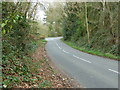
Greenhurst Lane junction with West Chiltington Road
Image: © Dave Spicer
Taken: 17 Jan 2010
0.05 miles
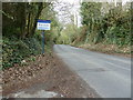
5
Greenhurst Lane junction with West Chiltington Road
Image: © Dave Spicer
Taken: 2 Apr 2011
0.06 miles
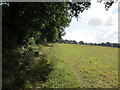
6
Looking south on Fryern Road
This is also the boundary between the parishes of Storrington and Sullington.
Image: © Dave Spicer
Taken: 2 Apr 2011
0.09 miles
7
Route to Jacket's Hill
Public footpath 2463/1.
Image: © Peter Holmes
Taken: 3 Aug 2013
0.09 miles
8
Fallen tree by course of old Roman Road
The path of the road was diagonally from top left to bottom right in this photo
Image: © Dave Spicer
Taken: 17 Jan 2010
0.10 miles
9
Bus stop, West Chiltington Road
Northbound for Stagecoach service 1 to Midhurst and southbound (unmarked) for buses to Worthing. Also Compass bus service 74 to Horsham (northbound) and Storrington (southbound).
Image: © Peter Holmes
Taken: 20 Jul 2013
0.12 miles
10
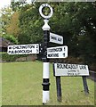
Direction Sign ? Signpost
Located on the northeast side of the junction of Roundabout Lane and Monkmead Lane in West Chiltington parish. 3 arms and annulus finial.
Milestone Society National ID: SX_TQ0816
Image: © J Chisholm
Taken: 24 Oct 2019
0.15 miles