IMAGES TAKEN NEAR TO
Furze Common Road, PULBOROUGH, RH20 3EG
Introduction
This page details the photographs taken nearby to Furze Common Road, RH20 3EG by members of the Geograph project.
The Geograph project started in 2005 with the aim of publishing, organising and preserving representative images for every square kilometre of Great Britain, Ireland and the Isle of Man.

There are currently over 7.5m images from over14,400 individuals and you can help contribute to the project by visiting https://www.geograph.org.uk
Image Map
Images are licensed for reuse under creativecommons.org/licenses/by-sa/2.0
Notes
- Clicking on the map will re-center to the selected point.
- The higher the marker number, the further away the image location is from the centre of the postcode.
Image Listing (8 Images Found)
Images are licensed for reuse under creativecommons.org/licenses/by-sa/2.0
Image
Details
Distance
1
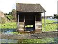
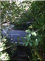
Partially submerged bus shelter at Abingworth
Set well back from the bus stop behind the fence
Image: © Dave Spicer
Taken: 17 Jan 2010
0.11 miles
2
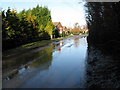
B2139 on the southern edge of Abingworth
Image: © Dave Spicer
Taken: 17 Jan 2010
0.12 miles
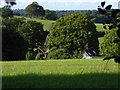
3
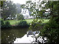
Abingworth Hall, by the B2139 Storrington Road
Viewed from the lake that lies alongside the road. The country house is run by Holiday Fellowship Holidays Ltd.
Image: © pam fray
Taken: 17 Sep 2008
0.18 miles
4
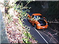
Birds eye view of traffic
From the footpath alongside the B2139.
Image: © Dave Spicer
Taken: 17 Jan 2010
0.21 miles
5
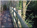
Safety fence on side of footpath high above the B2139 at Abingworth
Image: © Dave Spicer
Taken: 17 Jan 2010
0.21 miles
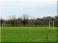
8
Champions Farm seen from footpath to the south
Image: © Shazz
Taken: 28 Aug 2015
0.25 miles