IMAGES TAKEN NEAR TO
Church Close, PULBOROUGH, RH20 3DL
Introduction
This page details the photographs taken nearby to Church Close, RH20 3DL by members of the Geograph project.
The Geograph project started in 2005 with the aim of publishing, organising and preserving representative images for every square kilometre of Great Britain, Ireland and the Isle of Man.

There are currently over 7.5m images from over14,400 individuals and you can help contribute to the project by visiting https://www.geograph.org.uk
Image Map
Images are licensed for reuse under creativecommons.org/licenses/by-sa/2.0
Notes
- Clicking on the map will re-center to the selected point.
- The higher the marker number, the further away the image location is from the centre of the postcode.
Image Listing (72 Images Found)
Images are licensed for reuse under creativecommons.org/licenses/by-sa/2.0
Image
Details
Distance
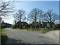
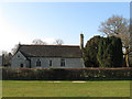
1
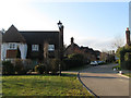
Church Close
A cul de sac that heads south off Church Lane that was built during the 2000s on what was once Alehouse Field, according to Ashington's 1847 tithe map.
Image: © Simon Carey
Taken: 2 Apr 2013
0.01 miles
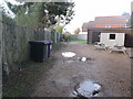
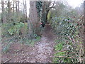
2
Footpath to Mitchbourne Farm
Route of public footpath 2611.
Image: © Peter Holmes
Taken: 8 Feb 2014
0.04 miles
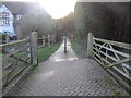
3
Footpath back of Ashington Social Club
Public footpath 3208 to Church Lane.
Image: © Peter Holmes
Taken: 8 Feb 2014
0.04 miles
4
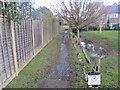
Path adjacent to drain
Public footpath 3208 to Mill Lane.
Image: © Peter Holmes
Taken: 8 Feb 2014
0.04 miles
5
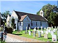
St Peter & St Paul Church, Ashington
details: http://www.achurchnearyou.com/ashington-st-peter-st-paul/
Image: © Paul Gillett
Taken: 13 Sep 2012
0.05 miles
6
Path to Spring Copse
Public footpath 2613.
Image: © Peter Holmes
Taken: 8 Feb 2014
0.05 miles
7
The Parish Church of St Peter and St Paul
The church is a Grade II* (star) listed building. See https://historicengland.org.uk/listing/the-list/list-entry/1027442
Image: © Chris Thomas-Atkin
Taken: 5 Sep 2021
0.06 miles
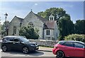
8
Road running past Ashington parish church
Image: © Basher Eyre
Taken: 12 Mar 2011
0.06 miles
9
Church of St Peter and St Paul
Much of the current church dates from a rebuild and enlargement in the early 1870s. Prior to that most of the rest dates from the 15th century onwards. Originally Ashington was a chapelry within the parish of Washington but was granted parochial status in its own right from 1190 onwards. The original church was built next to Ashington Common and its enclosure in 1816 would result in the growth of modern Ashington village and as a result the need to rebuild and extend the old church.
Image: © Simon Carey
Taken: 2 Apr 2013
0.06 miles
10
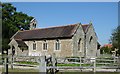
St Peter and St Paul's Church, Ashington
Extended in 1871. One of the bells (the stocks for which were renewed for the millennium) dates back to 1350.
Image: © Janine Forbes
Taken: 31 Aug 2005
0.06 miles