IMAGES TAKEN NEAR TO
North Lane, PULBOROUGH, RH20 3DF
Introduction
This page details the photographs taken nearby to North Lane, RH20 3DF by members of the Geograph project.
The Geograph project started in 2005 with the aim of publishing, organising and preserving representative images for every square kilometre of Great Britain, Ireland and the Isle of Man.

There are currently over 7.5m images from over14,400 individuals and you can help contribute to the project by visiting https://www.geograph.org.uk
Image Map
Images are licensed for reuse under creativecommons.org/licenses/by-sa/2.0
Notes
- Clicking on the map will re-center to the selected point.
- The higher the marker number, the further away the image location is from the centre of the postcode.
Image Listing (35 Images Found)
Images are licensed for reuse under creativecommons.org/licenses/by-sa/2.0
Image
Details
Distance
1
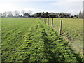
Bridleway going south at Brownhill
A similar view is at http://www.geograph.org.uk/photo/1320097.
Image: © Shazz
Taken: 17 Sep 2015
0.02 miles
2
Junction of footpath and bridleway at Brownhill
Image: © Shazz
Taken: 17 Sep 2015
0.03 miles
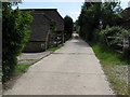
3
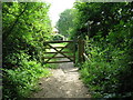
Route to Wiston
North Lane, public Bridleway 2500.
Image: © Peter Holmes
Taken: 8 Feb 2014
0.03 miles

6

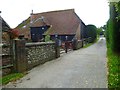
Brownhill House
A modern looking house on North Lane.
Image: © Simon Carey
Taken: 31 Mar 2013
0.05 miles
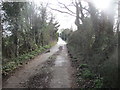
7
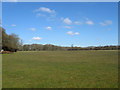
Approaching Brownhill
Public footpath 2511.
Image: © Peter Holmes
Taken: 8 Feb 2014
0.05 miles
9

Hut on stilts at Brownhill
To the right of the hut there was some kind of show-jumping area - so maybe the hut offers a good view over the proceedings?
Image: © Ian Hawfinch
Taken: 27 Apr 2020
0.06 miles
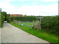
10
Cow Field
The name of the field according to Ashington's 1847 tithe map that lies to the immediate north of Brownhill House.
Image: © Simon Carey
Taken: 31 Mar 2013
0.07 miles