IMAGES TAKEN NEAR TO
Crossways, PULBOROUGH, RH20 2QY
Introduction
This page details the photographs taken nearby to Crossways, RH20 2QY by members of the Geograph project.
The Geograph project started in 2005 with the aim of publishing, organising and preserving representative images for every square kilometre of Great Britain, Ireland and the Isle of Man.

There are currently over 7.5m images from over14,400 individuals and you can help contribute to the project by visiting https://www.geograph.org.uk
Image Map (Loading...)


Getting Data...Please wait
Leaflet Map data © OpenStreetMap
Images are licensed for reuse under creativecommons.org/licenses/by-sa/2.0
Notes
- Clicking on the map will re-center to the selected point.
- The higher the marker number, the further away the image location is from the centre of the postcode.
Image Listing (4 Images Found)
Images are licensed for reuse under creativecommons.org/licenses/by-sa/2.0
Image
Details
Distance
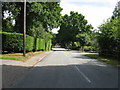
2
Lordings Lane
Public bridleway 2469 on private road.
Image: © Peter Holmes
Taken: 3 Aug 2013
0.22 miles
3
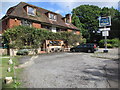
The Five Bells Inn, Smock Alley
A country Inn with a good selection of real ale and five en-suite rooms all with countryside views.
Image: © Peter Holmes
Taken: 3 Aug 2013
0.22 miles
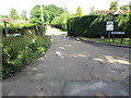
4
Smock Alley
Small hamlet in West Chiltington parish based around a lane of the same name. In the picture this is the one that starts at the bridge and heads north.
Image: © Simon Carey
Taken: 23 Sep 2006
0.23 miles