IMAGES TAKEN NEAR TO
Monkmead Lane, PULBOROUGH, RH20 2PF
Introduction
This page details the photographs taken nearby to Monkmead Lane, RH20 2PF by members of the Geograph project.
The Geograph project started in 2005 with the aim of publishing, organising and preserving representative images for every square kilometre of Great Britain, Ireland and the Isle of Man.

There are currently over 7.5m images from over14,400 individuals and you can help contribute to the project by visiting https://www.geograph.org.uk
Image Map
Images are licensed for reuse under creativecommons.org/licenses/by-sa/2.0
Notes
- Clicking on the map will re-center to the selected point.
- The higher the marker number, the further away the image location is from the centre of the postcode.
Image Listing (10 Images Found)
Images are licensed for reuse under creativecommons.org/licenses/by-sa/2.0
Image
Details
Distance

2
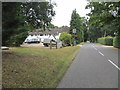
Roundabout Hotel, Monkmead Lane
Part of Best Western Hotels chain.
Image: © Peter Holmes
Taken: 20 Jul 2013
0.12 miles
3
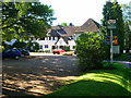
Roundabout Hotel
Built in 1927 in the style of a Tudor country mansion and named after a local farm rather than an actual roundabout.
Image: © Simon Carey
Taken: 23 Sep 2006
0.12 miles
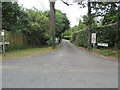
4
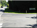
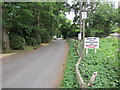
Looking eastwards on Monkmead Lane from Westward Lane
Image: © Shazz
Taken: 22 Aug 2015
0.15 miles
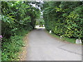
6
Sunset Lane
Public bridleway 2639 private lane.
Image: © Peter Holmes
Taken: 20 Jul 2013
0.20 miles
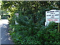
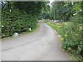
7
Spinney Lane looking north
Public footpath 2438.
Image: © Peter Holmes
Taken: 20 Jul 2013
0.20 miles
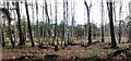
8
Spinney Lane looking east
Public footpath 2641 adjacent to Perrett's Copse.
Image: © Peter Holmes
Taken: 20 Jul 2013
0.23 miles
10
Spinney Lane looking south
Public footpath 2641 on private road.
Image: © Peter Holmes
Taken: 20 Jul 2013
0.24 miles