IMAGES TAKEN NEAR TO
Harbolets Road, PULBOROUGH, RH20 2LQ
Introduction
This page details the photographs taken nearby to Harbolets Road, RH20 2LQ by members of the Geograph project.
The Geograph project started in 2005 with the aim of publishing, organising and preserving representative images for every square kilometre of Great Britain, Ireland and the Isle of Man.

There are currently over 7.5m images from over14,400 individuals and you can help contribute to the project by visiting https://www.geograph.org.uk
Image Map (Loading...)


Getting Data...Please wait
Leaflet Map data © OpenStreetMap
Images are licensed for reuse under creativecommons.org/licenses/by-sa/2.0
Notes
- Clicking on the map will re-center to the selected point.
- The higher the marker number, the further away the image location is from the centre of the postcode.
Image Listing (20 Images Found)
Images are licensed for reuse under creativecommons.org/licenses/by-sa/2.0
Image
Details
Distance
1
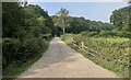
Track to Great Danhill Wood
The track viewed from Harbolets Road.
Image: © Chris Thomas-Atkin
Taken: 5 Sep 2021
0.07 miles
2
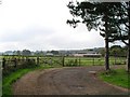
Danhill Farm
Seen from farm entrance on Harbolets Road (B2133) near junction with Coolham Road (B2139).
Image: © Andy Potter
Taken: 10 Oct 2006
0.08 miles
3
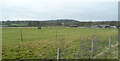
Pasture land near Danhill Farm
In the distance is Woods Hill.
Image: © Jonathan Billinger
Taken: 29 Jan 2008
0.14 miles
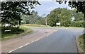
4
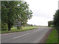
Junction of Harbolets Road and Coolham Road
From Harbolets Road (B2133) near Imagewith the Coolham Road (B2139) crossing left to right in the middle distance.
Image: © Andy Potter
Taken: 10 Oct 2006
0.15 miles
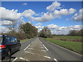
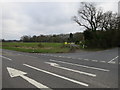
5

The B2133 crosses the B2139
In about 1970 the B2133 to the left (out of sight) was moved to produce a staggered crossroads. To the right it remains in its old position.
Image: © Robin Webster
Taken: 3 Jun 2011
0.17 miles
6
Coolham Road
The junction of Goose Green Lane with Coolham Road.
Image: © Chris Thomas-Atkin
Taken: 5 Sep 2021
0.17 miles
7
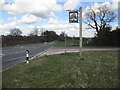
Thakeham Village Sign
North of village on Coolham Road (B2139) at junction with Goosegreen Lane (B2133).
Image: © Peter Holmes
Taken: 1 Mar 2014
0.17 miles
8
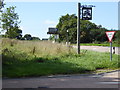
Thakeham village sign by Coolham Road
A view the other way is at http://www.geograph.org.uk/photo/3891419.
Image: © Shazz
Taken: 8 Sep 2015
0.17 miles
10
Public Footpath
FP2360 (2.356km) heading towards Apsley Farm
Image: © The Saunterer
Taken: 10 Mar 2013
0.19 miles