IMAGES TAKEN NEAR TO
Sinnocks, PULBOROUGH, RH20 2JX
Introduction
This page details the photographs taken nearby to Sinnocks, RH20 2JX by members of the Geograph project.
The Geograph project started in 2005 with the aim of publishing, organising and preserving representative images for every square kilometre of Great Britain, Ireland and the Isle of Man.

There are currently over 7.5m images from over14,400 individuals and you can help contribute to the project by visiting https://www.geograph.org.uk
Image Map
Images are licensed for reuse under creativecommons.org/licenses/by-sa/2.0
Notes
- Clicking on the map will re-center to the selected point.
- The higher the marker number, the further away the image location is from the centre of the postcode.
Image Listing (14 Images Found)
Images are licensed for reuse under creativecommons.org/licenses/by-sa/2.0
Image
Details
Distance
1
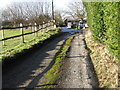
Footpath junction with Southlands Lane West Chiltington
Image: © Dave Spicer
Taken: 17 Jan 2010
0.05 miles
3
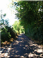
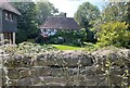
Sinnocks
This lane to the east of the village is named after a former common. Taken from the junction with Juggs Lane.
Image: © Simon Carey
Taken: 23 Sep 2006
0.11 miles
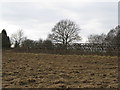
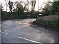
4
Signs at minor road junction
The road to the left continues to Smock Alley.
Image: © Dave Spicer
Taken: 28 Feb 2009
0.11 miles
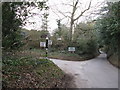
5
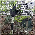
Direction Sign ? Signpost
Located on the southeast side of the junction of East Street and Sinnocks in West Chiltington parish. 3 arms and lost annulus finial. See also https://www.geograph.org.uk/photo/1183791.
Milestone Society National ID: SX_TQ0918
Image: © J Blemings
Taken: 13 Nov 2019
0.11 miles
7
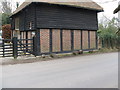
Patterned brickwork
On converted barn at Nalbrett's farm
Image: © Dave Spicer
Taken: 28 Feb 2009
0.16 miles
8
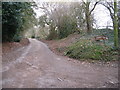
Track to Oakwood Farm
Looking north towards Oakwood Farm from a lane that connects West Chiltington to the B2139
Image: © Dave Spicer
Taken: 28 Feb 2009
0.16 miles
9
Naldretts Farmhouse
The farmhouse viewed from roadside. It is a Grade II listed building. See https://historicengland.org.uk/listing/the-list/list-entry/1027174
Image: © Chris Thomas-Atkin
Taken: 5 Sep 2021
0.17 miles
10
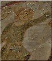
West Chiltington: St. Mary's Church: Wall paintings 1250-1275
Detail of the left hand tormentor in "The Flagellation" scene of the Passion Cycle. His facial expression says everything.
Image: © Michael Garlick
Taken: 9 Jul 2015
0.17 miles