IMAGES TAKEN NEAR TO
Gay Street Lane, PULBOROUGH, RH20 2HN
Introduction
This page details the photographs taken nearby to Gay Street Lane, RH20 2HN by members of the Geograph project.
The Geograph project started in 2005 with the aim of publishing, organising and preserving representative images for every square kilometre of Great Britain, Ireland and the Isle of Man.

There are currently over 7.5m images from over14,400 individuals and you can help contribute to the project by visiting https://www.geograph.org.uk
Image Map
Images are licensed for reuse under creativecommons.org/licenses/by-sa/2.0
Notes
- Clicking on the map will re-center to the selected point.
- The higher the marker number, the further away the image location is from the centre of the postcode.
Image Listing (7 Images Found)
Images are licensed for reuse under creativecommons.org/licenses/by-sa/2.0
Image
Details
Distance
1
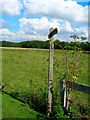
Footpath to Gay Street
Taken from the point where the path leaves the drive to Westlands Farm. Another signpost stands in the middle at the point when the path turns eastward.
Image: © Simon Carey
Taken: 23 Sep 2006
0.13 miles
2

This I believe is Beedings
A house described as monumental, in a newspaper article, where some early Neanderthal tools were discovered during its construction
Image: © Dave Spicer
Taken: 7 Mar 2009
0.14 miles
3
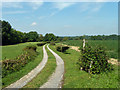
Drive to Westlands Farm
The farm is quite a long way from public roads.
Image: © Robin Webster
Taken: 2 Sep 2011
0.14 miles
4

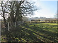
Path crossing field
Public footpath 2319 to Beeding's Farm.
Image: © Peter Holmes
Taken: 7 Mar 2015
0.15 miles
5
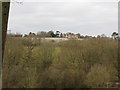
View across valley to houses and vineyard
The houses and vineyard I think are Lowerhill Farm
Image: © Dave Spicer
Taken: 28 Feb 2009
0.16 miles
6
Path approaching gate
Public footpath 2319 to Beeding's Farm.
Image: © Peter Holmes
Taken: 7 Mar 2015
0.18 miles
7
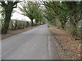
Avenue of Ivy clad trees
SE of North Heath
Image: © Dave Spicer
Taken: 7 Mar 2009
0.21 miles