IMAGES TAKEN NEAR TO
Rackham, PULBOROUGH, RH20 2EU

Introduction

This page details the photographs taken nearby to RH20 2EU by members of the Geograph project.

The Geograph project started in 2005 with the aim of publishing, organising and preserving representative images for every square kilometre of Great Britain, Ireland and the Isle of Man.

There are currently over 7.5m images from over14,400 individuals and you can help contribute to the project by visiting https://www.geograph.org.uk

Image Map


Images are licensed for reuse under creativecommons.org/licenses/by-sa/2.0
Notes
  • Clicking on the map will re-center to the selected point.
  • The higher the marker number, the further away the image location is from the centre of the postcode.

Image Listing (35 Images Found)

Images are licensed for reuse under creativecommons.org/licenses/by-sa/2.0
  • ...
Image
Details
Distance
1
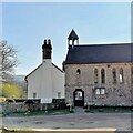
The Old School House
Image: © Ian Hawfinch Taken: 29 Jul 2020
0.00 miles
2
School House and Old School
The School House is on the left and the Old School is on the right.
Image: © Ian Hawfinch Taken: 24 Mar 2022
0.01 miles
3
Rackham Old School
Image: © Dave Spicer Taken: 30 May 2009
0.02 miles
4
Rackham Old School, Sussex
Former school building, located just off Rackham Street.
Image: © Peter Trimming Taken: 13 Sep 2011
0.02 miles
5
Sandstone at Rackham, Sussex
Sandstone formation, located close to Rackham Old School; much weathered.
Image: © Peter Trimming Taken: 13 Sep 2011
0.02 miles
6
Rackham Street
Route of West Sussex Literary Trail proceeding up hill towards West Lodges and Parham House. Trail continues west along public footpath 2676.
Image: © Peter Holmes Taken: 21 Mar 2015
0.02 miles
7
Folkestone Formation at Rackham
Sandstone from the Folkestone Formation of the Lower Greensand Group.
Image: © Tom Walsingham Taken: 11 Oct 2009
0.03 miles
8
Impressive sand cliff: Folkestone Formation off Rackham Street
Apparently it is sandstone from the Folkestone Formation of the Lower Greensand Group. The glorious golden cliff came "out of the blue", opposite the old school - quite a surprise. At the bottom it dissolves into a pile of the finest sand. Bucket and spade provided. Must have been heaven for the school kids of yore. Not a mention of this curiosity anywhere in the local tourist information. Eventually I found Tom Walsingham's 2009 photo Image, so pale without the sun on it that I did not spot it at first.
Image: © Chris Taken: 14 Jun 2014
0.04 miles
9
Impressive sand cliff: Folkestone Formation off Rackham Street
Apparently it is sandstone from the Folkestone Formation of the Lower Greensand Group. The glorious golden cliff came "out of the blue", opposite the old school - quite a surprise. At the bottom it dissolves into a pile of the finest sand. Bucket and spade provided. Must have been heaven for the school kids of yore. Not a mention of this curiosity anywhere in the local tourist information. Eventually I found Tom Walsingham's 2009 photo Image, so pale without the sun on it that I did not spot it at first.
Image: © Chris Taken: 14 Jun 2014
0.05 miles
10
Parham: Old WSCC signpost
This old West Sussex County Council (WSCC) signpost is in a triangular island on Rackham Street at its junction with a lane to Greatham. Curiously at the end of the lane in Greatham is Image which shows Amberley one way, down the lane to here, and Storrington another, whereas here they are in the same direction... Anyway the full directions, reading like the results in Division 7 of the West Sussex Football League, are: Amberley 2 Storrington 3 (to the right) Greatham 2 Coldwaltham 3 (to the left) and finally the delightfully named Wiggonholt 2 to the far left.
Image: © Nigel Cox Taken: 17 Sep 2009
0.10 miles
  • ...