IMAGES TAKEN NEAR TO
Lower Street, PULBOROUGH, RH20 2BH
Introduction
This page details the photographs taken nearby to Lower Street, RH20 2BH by members of the Geograph project.
The Geograph project started in 2005 with the aim of publishing, organising and preserving representative images for every square kilometre of Great Britain, Ireland and the Isle of Man.

There are currently over 7.5m images from over14,400 individuals and you can help contribute to the project by visiting https://www.geograph.org.uk
Image Map
Images are licensed for reuse under creativecommons.org/licenses/by-sa/2.0
Notes
- Clicking on the map will re-center to the selected point.
- The higher the marker number, the further away the image location is from the centre of the postcode.
Image Listing (104 Images Found)
Images are licensed for reuse under creativecommons.org/licenses/by-sa/2.0
Image
Details
Distance
1
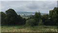
Open Space
Open space in Pulborough with the South Downs far in the distance.
Image: © Chris Thomas-Atkin
Taken: 3 Sep 2017
0.07 miles
2
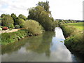
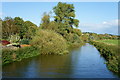
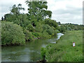
River Arun from Pulborough Bridge
Despite being tidal the river is shallow enough here for the vegetation growing in the middle to be seen beneath the surface. For a view looking in the opposite direction please see Graham's Image
Image: © Nigel Cox
Taken: 17 Sep 2009
0.08 miles
3
View downstream on the River Arun from the old Pulborough bridge
Image: © Dave Spicer
Taken: 11 Jun 2011
0.08 miles
5
River Arun, Pulborough, Sussex
Looking downstream, from the old Pulborough Bridge. A fisherman is lurking on the right-hand river bank.
Image: © Peter Trimming
Taken: 13 Sep 2011
0.08 miles
6
The Old House, Pulborough
Grade II listed: http://www.britishlistedbuildings.co.uk/en-298531-the-old-house-pulborough-west-sussex
Image: © David960
Taken: 21 Apr 2014
0.08 miles
7
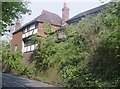
Church Hill
With one of Pulborough's older buildings perched precariously on the hillside. Unfortunately I forgot to take a note of the name of the house.
Image: © Simon Carey
Taken: 22 Dec 2006
0.08 miles
8
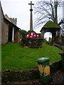
War Memorial and Lychgate
The lychgate is from the 14th century and has a Horsham slate roof. The 13th century church's tower can just be viewed to the left. At least someone has tried to add colour to the wheelie bin.
Image: © Simon Carey
Taken: 22 Dec 2006
0.08 miles
9
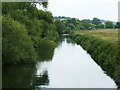
River Arun downstream of Pulborough Swan Bridge
The river is still tidal here.
Image: © Robin Webster
Taken: 23 May 2011
0.09 miles
10
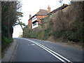
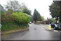
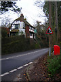
Nearing the top of Church Hill
This section of the A29 cuts deeply into the hill to reduce the gradient. The revetted bank below the house suggests that the building pre-dates the lowering of the road. The Roman road, latterly known by its Saxon name of Stane Street, may have been lowered here by Napoleonic prisoners of war.
Image: © Andy Potter
Taken: 28 Feb 2009
0.09 miles