IMAGES TAKEN NEAR TO
Bury Gate, PULBOROUGH, RH20 1NY
Introduction
This page details the photographs taken nearby to Bury Gate, RH20 1NY by members of the Geograph project.
The Geograph project started in 2005 with the aim of publishing, organising and preserving representative images for every square kilometre of Great Britain, Ireland and the Isle of Man.

There are currently over 7.5m images from over14,400 individuals and you can help contribute to the project by visiting https://www.geograph.org.uk
Image Map
Images are licensed for reuse under creativecommons.org/licenses/by-sa/2.0
Notes
- Clicking on the map will re-center to the selected point.
- The higher the marker number, the further away the image location is from the centre of the postcode.
Image Listing (15 Images Found)
Images are licensed for reuse under creativecommons.org/licenses/by-sa/2.0
Image
Details
Distance
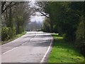
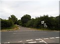
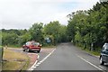
2
Road Junction A29
Turn left for Fittleworth and Petworth (B2138).
Image: © Peter Holmes
Taken: 14 Mar 2013
0.07 miles
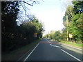
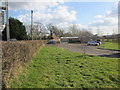
4
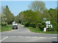
Crossroads near Watersfield
Looking towards a far junction with the A29 towards London.
Image: © Robin Webster
Taken: 21 Apr 2011
0.08 miles
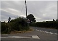
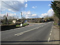
8
Sussex Farm Foods, Bury Gate
Farm produce shop specializing in locally-sourced fresh fruit and vegetables, meat and fish, bread and cakes, cheese, flowers and plants.
Image: © Peter Holmes
Taken: 14 Mar 2013
0.10 miles